Bergfeld geodata
Bergfeld (Lower Saxony) is a seat of a fourth-order administrative division; located in Germany in Europe/Berlin (GMT+2) time zone. With population of 956 people, there are 7323 cities with bigger population in this country. Compared to other cities in Germany, 78% of cities are located further ↓South; 64.7% of cities are located further ←West and 73.8% of cities have higher elevation than Bergfeld. Note1


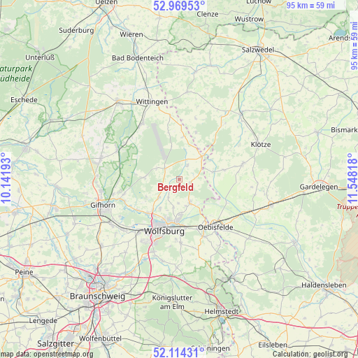
Bergfeld GPS coordinates[2]
52° 32' 38.4" North, 10° 50' 42.18" East
| Map corner | latitude | longitude |
|---|---|---|
| Upper-left | 52.96953°, | 10.14193° |
| Center: | 52.544°, | 10.84505° |
| Lower-right: | 52.11431°, | 11.54818° |
| Map W x H: | 95.1×95.1 km | = 59.1×59.1mi |
| max Lat: | 55.01917° ⇑22% North |
| Bergfeld: | 52.544° |
| min Lat: | ⇓78% South 47.40724° |
| min Long | Bergfeld | max Long |
| 5.92978° | 10.84505° | 14.98853° |
| W 64.7%⇐ | ⇒35.3% E |
Elevation
Elevation of Bergfeld is 68 m = 223 ft, and this is 181.1 m = 594 ft below average elevation for this country.
| Max E: |
1256 m = 4121 ft | 73.8% |
| Avg. | 249.1 m = 817 ft | |
| Bergfeld | 68 m = 223 ft | |
Min E: |
-5 m = -16 ft | 26.2% |
See also: Germany elevation on elevation.city.
Geographical zone
Bergfeld is located in North temperate zone (between Tropic of Cancer and the Arctic Circle). Distance of this North polar circle is 1558.8 km =968.6 mi to North.| Distance of | km | miles | from Bergfeld |
|---|---|---|---|
| North Pole | 4164.7 | 2587.8 | to North |
| Arctic Circle | 1558.8 | 968.6 | to North |
| Tropic Cancer | 3236.4 | 2011 | to South |
| Equator | 5842.3 | 3630.2 | to South |


Nearby cities:
15 places around Bergfeld: (largest is in red/bold)
• Barwedel
5.3 km =3.3 mi,  242°
242°
• Bokensdorf
10 km =6.2 mi, 240°
• Brome
8.8 km =5.5 mi,  45°
45°
• Grafhorst
12.9 km =8 mi,  148°
148°
• Jahrstedt
9.1 km =5.7 mi,  78°
78°
• Jembke
7.2 km =4.5 mi,  227°
227°
• Kunrau
12 km =7.5 mi, 77°
• Osloß
13.9 km =8.6 mi, 233°
• Parsau
3.2 km =2 mi,  108°
108°
• Rothenfelde
13.5 km =8.4 mi,  194°
194°
• Rühen
7.1 km =4.4 mi,  156°
156°
• Tappenbeck
10.8 km =6.7 mi,  220°
220°
• Tiddische
4.3 km =2.7 mi, 225°
• Tülau
4.2 km =2.6 mi,  32°
32°
• Weyhausen
12.6 km =7.8 mi, 223°
Sources, notices
• [Note1] Compared only with cities in Germany existing in our database
• [Src1] Map data: © OpenStreetMap contributors (CC-BY-SA)
• [Src2] Other city data from geonames.org with taken over terms of usage.
• [Src3] Geographical zone / Annual Mean Temperature by Robert A. Rohde @ Wikipedia
