Fischbachau geodata
Fischbachau (Bavaria) is a seat of a fourth-order administrative division; located in Germany in Europe/Berlin (GMT+2) time zone. With population of 5,471 people, there are 2638 cities with bigger population in this country. Compared to other cities in Germany, 98.6% of cities are located further ↑North; 81.2% of cities are located further ←West and 98.9% of cities have lower elevation than Fischbachau. Note1
Administrative division(s):
- Level 1: Bavaria
- Level 2: Upper Bavaria
- Level 3: Landkreis Miesbach
- Level 4: Fischbachau


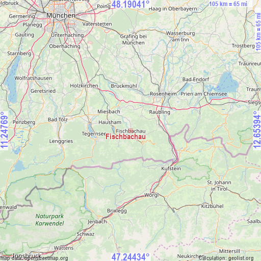
Fischbachau GPS coordinates[2]
47° 43' 10.272" North, 11° 57' 2.916" East
| Map corner | latitude | longitude |
|---|---|---|
| Upper-left | 48.19041°, | 11.24769° |
| Center: | 47.71952°, | 11.95081° |
| Lower-right: | 47.24434°, | 12.65394° |
| Map W x H: | 105.2×105.2 km | = 65.4×65.4mi |
| max Lat: | 55.01917° ⇑98.6% North |
| Fischbachau: | 47.71952° |
| min Lat: | ⇓1.4% South 47.40724° |
| min Long | Fischbachau | max Long |
| 5.92978° | 11.95081° | 14.98853° |
| W 81.2%⇐ | ⇒18.8% E |
Elevation
Elevation of Fischbachau is 774 m = 2539 ft, and this is 524.9 m = 1722 ft above average elevation for this country.
| Max E: |
1256 m = 4121 ft | 1.1% |
| Fischbachau | 774 m 2539 ft | |
| Avg. | 249.1 m = 817 ft | |
Min E: |
-5 m = -16 ft | 98.9% |
See also: Germany elevation on elevation.city.
Geographical zone
Fischbachau is located in North temperate zone (between Tropic of Cancer and the Arctic Circle). Distance of this North polar circle is 2095.3 km =1302 mi to North.| Distance of | km | miles | from Fischbachau |
|---|---|---|---|
| North Pole | 4701.1 | 2921.1 | to North |
| Arctic Circle | 2095.3 | 1302 | to North |
| Tropic Cancer | 2700 | 1677.7 | to South |
| Equator | 5305.9 | 3296.9 | to South |


Nearby cities:
15 places around Fischbachau: (largest is in red/bold)
• Altenmarkt
15.3 km =9.5 mi,  64°
64°
• Bad Feilnbach
7.4 km =4.6 mi,  36°
36°
• Bayrischzell
6.9 km =4.3 mi,  136°
136°
• Brannenburg
10.8 km =6.7 mi,  77°
77°
• Burg Unter-Falkenstein
11.6 km =7.2 mi,  98°
98°
• Flintsbach
13 km =8.1 mi,  86°
86°
• Hausham
8.8 km =5.5 mi,  290°
290°
• Irschenberg
12.9 km =8 mi,  348°
348°
• Miesbach
11.7 km =7.3 mi,  311°
311°
• Neubeuern
15.4 km =9.6 mi,  66°
66°
• Nußdorf am Inn
15.6 km =9.7 mi, 80°
• Raubling
14.3 km =8.9 mi, 56°
• Rottach-Egern
13.9 km =8.6 mi,  256°
256°
• Schliersee
7.1 km =4.4 mi, 285°
• Tegernsee
14.4 km =8.9 mi,  266°
266°
Sources, notices
• [Note1] Compared only with cities in Germany existing in our database
• [Src1] Map data: © OpenStreetMap contributors (CC-BY-SA)
• [Src2] Other city data from geonames.org with taken over terms of usage.
• [Src3] Geographical zone / Annual Mean Temperature by Robert A. Rohde @ Wikipedia
