Körchow geodata
Körchow (Mecklenburg-Vorpommern) is a populated place; located in Germany in Europe/Berlin (GMT+2) time zone. With population of 886 people, there are 7572 cities with bigger population in this country. Compared to other cities in Germany, 84.9% of cities are located further ↓South; 67.9% of cities are located further ←West and 74.7% of cities have higher elevation than Körchow. Note1
Administrative division(s):
- Level 1: Mecklenburg-Vorpommern
- Level 3: Ludwigslust-Parchim
- Level 4: Wittenburg


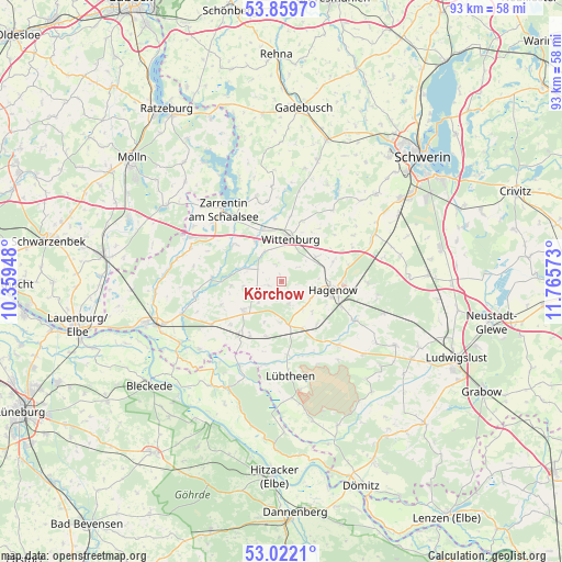
Körchow GPS coordinates[2]
53° 26' 34.656" North, 11° 3' 45.36" East
| Map corner | latitude | longitude |
|---|---|---|
| Upper-left | 53.8597°, | 10.35948° |
| Center: | 53.44296°, | 11.0626° |
| Lower-right: | 53.0221°, | 11.76573° |
| Map W x H: | 93.1×93.1 km | = 57.8×57.8mi |
| max Lat: | 55.01917° ⇑15.1% North |
| Körchow: | 53.44296° |
| min Lat: | ⇓84.9% South 47.40724° |
| min Long | Körchow | max Long |
| 5.92978° | 11.0626° | 14.98853° |
| W 67.9%⇐ | ⇒32.1% E |
Elevation
Elevation of Körchow is 64 m = 210 ft, and this is 185.1 m = 607 ft below average elevation for this country.
| Max E: |
1256 m = 4121 ft | 74.7% |
| Avg. | 249.1 m = 817 ft | |
| Körchow | 64 m = 210 ft | |
Min E: |
-5 m = -16 ft | 25.3% |
See also: Germany elevation on elevation.city.
Geographical zone
Körchow is located in North temperate zone (between Tropic of Cancer and the Arctic Circle). Distance of this North polar circle is 1458.9 km =906.5 mi to North.| Distance of | km | miles | from Körchow |
|---|---|---|---|
| North Pole | 4064.8 | 2525.7 | to North |
| Arctic Circle | 1458.9 | 906.5 | to North |
| Tropic Cancer | 3336.4 | 2073.1 | to South |
| Equator | 5942.3 | 3692.4 | to South |


Nearby cities:
15 places around Körchow: (largest is in red/bold)
• Besitz
17.5 km =10.9 mi,  230°
230°
• Dümmer
17.6 km =10.9 mi,  32°
32°
• Hagenow
8.6 km =5.3 mi,  98°
98°
• Kirch Jesar
14.3 km =8.9 mi,  90°
90°
• Kogel
9.6 km =6 mi,  309°
309°
• Kuhstorf
13.9 km =8.6 mi,  117°
117°
• Lübtheen
15.8 km =9.8 mi,  174°
174°
• Moraas
16.1 km =10 mi, 98°
• Pritzier
7.2 km =4.5 mi, 171°
• Redefin
14 km =8.7 mi,  138°
138°
• Setzin
3.8 km =2.4 mi,  160°
160°
• Toddin
5.7 km =3.5 mi, 118°
• Vellahn
7.9 km =4.9 mi, 233°
• Wittenburg
7.1 km =4.4 mi,  9°
9°
• Zarrentin
15.4 km =9.6 mi,  320°
320°
Sources, notices
• [Note1] Compared only with cities in Germany existing in our database
• [Src1] Map data: © OpenStreetMap contributors (CC-BY-SA)
• [Src2] Other city data from geonames.org with taken over terms of usage.
• [Src3] Geographical zone / Annual Mean Temperature by Robert A. Rohde @ Wikipedia
