Kogel geodata
Kogel (Mecklenburg-Vorpommern) is a populated place; located in Germany in Europe/Berlin (GMT+2) time zone. With population of 623 people, there are 8698 cities with bigger population in this country. Compared to other cities in Germany, 85.5% of cities are located further ↓South; 66.3% of cities are located further ←West and 85.4% of cities have higher elevation than Kogel. Note1
Administrative division(s):
- Level 1: Mecklenburg-Vorpommern
- Level 3: Ludwigslust-Parchim
- Level 4: Kogel


Kogel GPS coordinates[2]
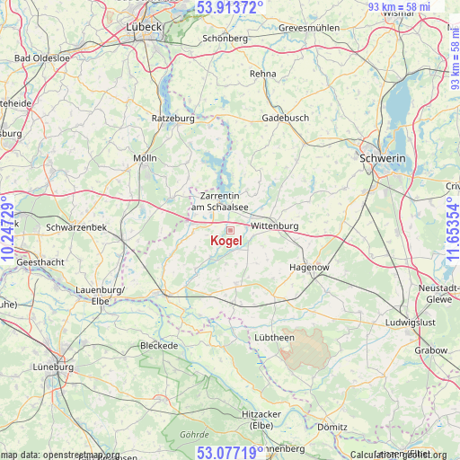
53° 29' 51.072" North, 10° 57' 1.476" East
| Map corner | latitude | longitude |
|---|---|---|
| Upper-left | 53.91372°, | 10.24729° |
| Center: | 53.49752°, | 10.95041° |
| Lower-right: | 53.07719°, | 11.65354° |
| Map W x H: | 93×93 km | = 57.8×57.8mi |
| max Lat: | 55.01917° ⇑14.5% North |
| Kogel: | 53.49752° |
| min Lat: | ⇓85.5% South 47.40724° |
| min Long | Kogel | max Long |
| 5.92978° | 10.95041° | 14.98853° |
| W 66.3%⇐ | ⇒33.7% E |
Elevation
Elevation of Kogel is 34 m = 112 ft, and this is 215.1 m = 706 ft below average elevation for this country.
| Max E: |
1256 m = 4121 ft | 85.4% |
| Avg. | 249.1 m = 817 ft | |
| Kogel | 34 m = 112 ft | |
Min E: |
-5 m = -16 ft | 14.6% |
See also: Germany elevation on elevation.city.
Geographical zone
Kogel is located in North temperate zone (between Tropic of Cancer and the Arctic Circle). Distance of this North polar circle is 1452.8 km =902.7 mi to North.| Distance of | km | miles | from Kogel |
|---|---|---|---|
| North Pole | 4058.7 | 2522 | to North |
| Arctic Circle | 1452.8 | 902.7 | to North |
| Tropic Cancer | 3342.4 | 2076.9 | to South |
| Equator | 5948.4 | 3696.2 | to South |


Nearby cities:
15 places around Kogel: (largest is in red/bold)
• Besenthal
14.9 km =9.3 mi,  285°
285°
• Gresse
15.5 km =9.6 mi,  240°
240°
• Gudow
13.5 km =8.4 mi,  298°
298°
• Hollenbek
13.5 km =8.4 mi,  320°
320°
• Klein Zecher
11 km =6.8 mi,  329°
329°
• Körchow
9.6 km =6 mi,  129°
129°
• Langenlehsten
13.9 km =8.6 mi,  271°
271°
• Pritzier
15.6 km =9.7 mi,  147°
147°
• Seedorf
14.7 km =9.1 mi,  337°
337°
• Setzin
13 km =8.1 mi,  137°
137°
• Sterley
15.9 km =9.9 mi, 326°
• Toddin
15.2 km =9.4 mi, 125°
• Vellahn
10.8 km =6.7 mi,  174°
174°
• Wittenburg
8.7 km =5.4 mi,  83°
83°
• Zarrentin
6.4 km =4 mi, 338°
Sources, notices
• [Note1] Compared only with cities in Germany existing in our database
• [Src1] Map data: © OpenStreetMap contributors (CC-BY-SA)
• [Src2] Other city data from geonames.org with taken over terms of usage.
• [Src3] Geographical zone / Annual Mean Temperature by Robert A. Rohde @ Wikipedia
