Zarrentin geodata
Zarrentin (Mecklenburg-Vorpommern) is a populated place; located in Germany in Europe/Berlin (GMT+2) time zone. With population of 3,243 people, there are 3793 cities with bigger population in this country. Compared to other cities in Germany, 86.2% of cities are located further ↓South; 65.7% of cities are located further ←West and 80.2% of cities have higher elevation than Zarrentin. Note1
Administrative division(s):
- Level 1: Mecklenburg-Vorpommern
- Level 3: Ludwigslust-Parchim
- Level 4: Zarrentin am Schaalsee


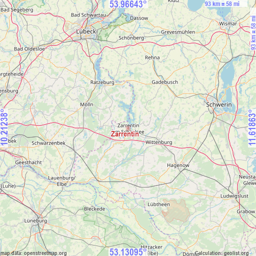
Zarrentin GPS coordinates[2]
53° 33' 2.7" North, 10° 54' 55.8" East
| Map corner | latitude | longitude |
|---|---|---|
| Upper-left | 53.96643°, | 10.21238° |
| Center: | 53.55075°, | 10.9155° |
| Lower-right: | 53.13095°, | 11.61863° |
| Map W x H: | 92.9×92.9 km | = 57.7×57.7mi |
| max Lat: | 55.01917° ⇑13.8% North |
| Zarrentin: | 53.55075° |
| min Lat: | ⇓86.2% South 47.40724° |
| min Long | Zarrentin | max Long |
| 5.92978° | 10.9155° | 14.98853° |
| W 65.7%⇐ | ⇒34.3% E |
Elevation
Elevation of Zarrentin is 46 m = 151 ft, and this is 203.1 m = 666 ft below average elevation for this country.
| Max E: |
1256 m = 4121 ft | 80.2% |
| Avg. | 249.1 m = 817 ft | |
| Zarrentin | 46 m = 151 ft | |
Min E: |
-5 m = -16 ft | 19.8% |
See also: Germany elevation on elevation.city.
Geographical zone
Zarrentin is located in North temperate zone (between Tropic of Cancer and the Arctic Circle). Distance of this North polar circle is 1446.9 km =899.1 mi to North.| Distance of | km | miles | from Zarrentin |
|---|---|---|---|
| North Pole | 4052.8 | 2518.3 | to North |
| Arctic Circle | 1446.9 | 899.1 | to North |
| Tropic Cancer | 3348.4 | 2080.6 | to South |
| Equator | 5954.3 | 3699.8 | to South |


Nearby cities:
15 places around Zarrentin: (largest is in red/bold)
• Besenthal
12.2 km =7.6 mi,  260°
260°
• Brunsmark
14.1 km =8.8 mi,  301°
301°
• Gudow
9.6 km =6 mi,  273°
273°
• Göttin
14.4 km =8.9 mi, 262°
• Hollenbek
7.7 km =4.8 mi,  305°
305°
• Kittlitz
12.6 km =7.8 mi,  0°
0°
• Klein Zecher
4.8 km =3 mi,  318°
318°
• Kogel
6.4 km =4 mi,  158°
158°
• Krembz
14.7 km =9.1 mi,  40°
40°
• Langenlehsten
12.8 km =8 mi,  244°
244°
• Lehmrade
12 km =7.5 mi,  293°
293°
• Salem
13.1 km =8.1 mi,  333°
333°
• Seedorf
8.3 km =5.2 mi,  336°
336°
• Sterley
9.8 km =6.1 mi, 318°
• Wittenburg
12 km =7.5 mi,  114°
114°
Sources, notices
• [Note1] Compared only with cities in Germany existing in our database
• [Src1] Map data: © OpenStreetMap contributors (CC-BY-SA)
• [Src2] Other city data from geonames.org with taken over terms of usage.
• [Src3] Geographical zone / Annual Mean Temperature by Robert A. Rohde @ Wikipedia
