Wittenburg geodata
Wittenburg (Mecklenburg-Vorpommern) is a populated place; located in Germany in Europe/Berlin (GMT+2) time zone. With population of 5,041 people, there are 2811 cities with bigger population in this country. Compared to other cities in Germany, 85.6% of cities are located further ↓South; 68.1% of cities are located further ←West and 81.4% of cities have higher elevation than Wittenburg. Note1
Administrative division(s):
- Level 1: Mecklenburg-Vorpommern
- Level 3: Ludwigslust-Parchim
- Level 4: Wittenburg


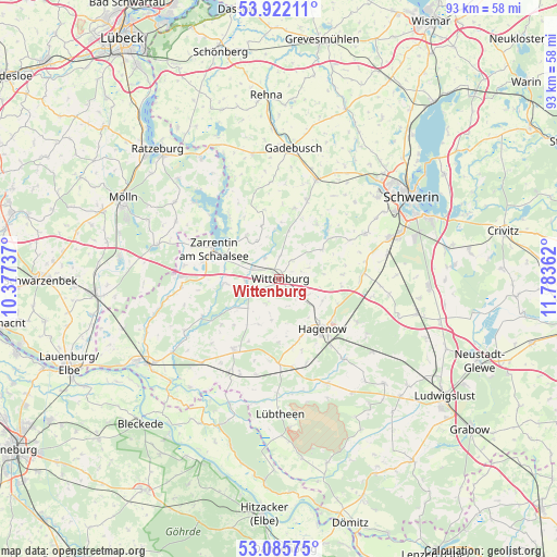
Wittenburg GPS coordinates[2]
53° 30' 21.564" North, 11° 4' 49.764" East
| Map corner | latitude | longitude |
|---|---|---|
| Upper-left | 53.92211°, | 10.37737° |
| Center: | 53.50599°, | 11.08049° |
| Lower-right: | 53.08575°, | 11.78362° |
| Map W x H: | 93×93 km | = 57.8×57.8mi |
| max Lat: | 55.01917° ⇑14.4% North |
| Wittenburg: | 53.50599° |
| min Lat: | ⇓85.6% South 47.40724° |
| min Long | Wittenburg | max Long |
| 5.92978° | 11.08049° | 14.98853° |
| W 68.1%⇐ | ⇒31.9% E |
Elevation
Elevation of Wittenburg is 43 m = 141 ft, and this is 206.1 m = 676 ft below average elevation for this country.
| Max E: |
1256 m = 4121 ft | 81.4% |
| Avg. | 249.1 m = 817 ft | |
| Wittenburg | 43 m = 141 ft | |
Min E: |
-5 m = -16 ft | 18.6% |
See also: Germany elevation on elevation.city.
Geographical zone
Wittenburg is located in North temperate zone (between Tropic of Cancer and the Arctic Circle). Distance of this North polar circle is 1451.9 km =902.2 mi to North.| Distance of | km | miles | from Wittenburg |
|---|---|---|---|
| North Pole | 4057.8 | 2521.4 | to North |
| Arctic Circle | 1451.9 | 902.2 | to North |
| Tropic Cancer | 3343.4 | 2077.5 | to South |
| Equator | 5949.3 | 3696.7 | to South |


Nearby cities:
15 places around Wittenburg: (largest is in red/bold)
• Dümmer
11.3 km =7 mi,  46°
46°
• Hagenow
11.1 km =6.9 mi,  138°
138°
• Kirch Jesar
15 km =9.3 mi,  118°
118°
• Klein Zecher
16.5 km =10.3 mi,  301°
301°
• Kogel
8.7 km =5.4 mi,  263°
263°
• Krembz
16.1 km =10 mi,  355°
355°
• Körchow
7.1 km =4.4 mi,  189°
189°
• Moraas
17.4 km =10.8 mi, 122°
• Pokrent
16.5 km =10.3 mi,  15°
15°
• Pritzier
14.1 km =8.8 mi,  180°
180°
• Setzin
10.6 km =6.6 mi, 179°
• Stralendorf
16.6 km =10.3 mi,  62°
62°
• Toddin
10.4 km =6.5 mi,  158°
158°
• Vellahn
13.9 km =8.6 mi,  212°
212°
• Zarrentin
12 km =7.5 mi,  294°
294°
Sources, notices
• [Note1] Compared only with cities in Germany existing in our database
• [Src1] Map data: © OpenStreetMap contributors (CC-BY-SA)
• [Src2] Other city data from geonames.org with taken over terms of usage.
• [Src3] Geographical zone / Annual Mean Temperature by Robert A. Rohde @ Wikipedia
