Klipphausen geodata
Klipphausen (Saxony) is a seat of a fourth-order administrative division; located in Germany in Europe/Berlin (GMT+2) time zone. With population of 6,161 people, there are 2409 cities with bigger population in this country. Compared to other cities in Germany, 59.4% of cities are located further ↓South; 95.8% of cities are located further ←West and 56.7% of cities have lower elevation than Klipphausen. Note1


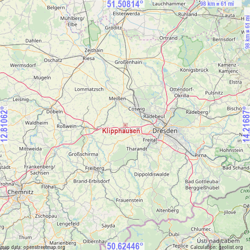
Klipphausen GPS coordinates[2]
51° 4' 6.276" North, 13° 30' 49.464" East
| Map corner | latitude | longitude |
|---|---|---|
| Upper-left | 51.50814°, | 12.81062° |
| Center: | 51.06841°, | 13.51374° |
| Lower-right: | 50.62446°, | 14.21687° |
| Map W x H: | 98.3×98.3 km | = 61.1×61.1mi |
| max Lat: | 55.01917° ⇑40.6% North |
| Klipphausen: | 51.06841° |
| min Lat: | ⇓59.4% South 47.40724° |
| min Long | Klipphausen | max Long |
| 5.92978° | 13.51374° | 14.98853° |
| W 95.8%⇐ | ⇒4.2% E |
Elevation
Elevation of Klipphausen is 270 m = 886 ft, and this is 20.9 m = 69 ft above average elevation for this country.
| Max E: |
1256 m = 4121 ft | 43.3% |
| Klipphausen | 270 m 886 ft | |
| Avg. | 249.1 m = 817 ft | |
Min E: |
-5 m = -16 ft | 56.7% |
See also: Germany elevation on elevation.city.
Geographical zone
Klipphausen is located in North temperate zone (between Tropic of Cancer and the Arctic Circle). Distance of this North polar circle is 1722.9 km =1070.6 mi to North.| Distance of | km | miles | from Klipphausen |
|---|---|---|---|
| North Pole | 4328.8 | 2689.8 | to North |
| Arctic Circle | 1722.9 | 1070.6 | to North |
| Tropic Cancer | 3072.4 | 1909.1 | to South |
| Equator | 5678.3 | 3528.3 | to South |


Nearby cities:
15 places around Klipphausen: (largest is in red/bold)
• Coswig
8.6 km =5.3 mi,  34°
34°
• Dorfhain
15.5 km =9.6 mi,  166°
166°
• Dresden
15.8 km =9.8 mi,  97°
97°
• Freital
12 km =7.5 mi,  128°
128°
• Meissen
10.7 km =6.6 mi,  344°
344°
• Moritzburg
15.4 km =9.6 mi,  49°
49°
• Niederau
12.3 km =7.6 mi,  10°
10°
• Niederschöna
13.1 km =8.1 mi,  210°
210°
• Nossen
15.2 km =9.4 mi,  265°
265°
• Rabenau
14.6 km =9.1 mi,  141°
141°
• Radebeul
11.1 km =6.9 mi,  67°
67°
• Reinsberg
12.3 km =7.6 mi,  237°
237°
• Tharandt
10.4 km =6.5 mi,  153°
153°
• Weinböhla
11.5 km =7.1 mi,  18°
18°
• Wilsdruff
2.4 km =1.5 mi, 138°
Sources, notices
• [Note1] Compared only with cities in Germany existing in our database
• [Src1] Map data: © OpenStreetMap contributors (CC-BY-SA)
• [Src2] Other city data from geonames.org with taken over terms of usage.
• [Src3] Geographical zone / Annual Mean Temperature by Robert A. Rohde @ Wikipedia
