Freital geodata
Freital (Saxony) is a populated place; located in Germany in Europe/Berlin (GMT+2) time zone. With population of 39,027 people, there are 334 cities with bigger population in this country. Compared to other cities in Germany, 58.2% of cities are located further ↓South; 96.6% of cities are located further ←West and 57.5% of cities have higher elevation than Freital. Note1


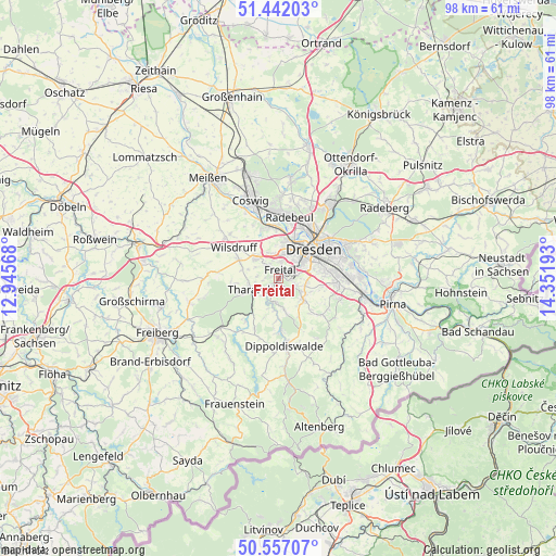
Freital GPS coordinates[2]
51° 0' 5.976" North, 13° 38' 55.68" East
| Map corner | latitude | longitude |
|---|---|---|
| Upper-left | 51.44203°, | 12.94568° |
| Center: | 51.00166°, | 13.6488° |
| Lower-right: | 50.55707°, | 14.35193° |
| Map W x H: | 98.4×98.4 km | = 61.1×61.1mi |
| max Lat: | 55.01917° ⇑41.8% North |
| Freital: | 51.00166° |
| min Lat: | ⇓58.2% South 47.40724° |
| min Long | Freital | max Long |
| 5.92978° | 13.6488° | 14.98853° |
| W 96.6%⇐ | ⇒3.4% E |
Elevation
Elevation of Freital is 171 m = 561 ft, and this is 78.1 m = 256 ft below average elevation for this country.
| Max E: |
1256 m = 4121 ft | 57.5% |
| Avg. | 249.1 m = 817 ft | |
| Freital | 171 m = 561 ft | |
Min E: |
-5 m = -16 ft | 42.5% |
See also: Germany elevation on elevation.city.
Geographical zone
Freital is located in North temperate zone (between Tropic of Cancer and the Arctic Circle). Distance of this North polar circle is 1730.3 km =1075.2 mi to North.| Distance of | km | miles | from Freital |
|---|---|---|---|
| North Pole | 4336.2 | 2694.4 | to North |
| Arctic Circle | 1730.3 | 1075.2 | to North |
| Tropic Cancer | 3064.9 | 1904.4 | to South |
| Equator | 5670.9 | 3523.7 | to South |


Nearby cities:
15 places around Freital: (largest is in red/bold)
• Albertstadt
12.3 km =7.6 mi,  42°
42°
• Bannewitz
4.9 km =3 mi,  101°
101°
• Coswig
15.2 km =9.4 mi,  342°
342°
• Dippoldiswalde
11.8 km =7.3 mi,  173°
173°
• Dorfhain
9.5 km =5.9 mi,  217°
217°
• Dresden
8.3 km =5.2 mi,  48°
48°
• Hermsdorf
10.6 km =6.6 mi,  145°
145°
• Klipphausen
12 km =7.5 mi,  308°
308°
• Kreischa
9.7 km =6 mi,  130°
130°
• Obercunnersdorf
11.3 km =7 mi,  213°
213°
• Rabenau
4.1 km =2.5 mi,  185°
185°
• Radebeul
11.7 km =7.3 mi,  4°
4°
• Reinhardtsgrimma
14.2 km =8.8 mi, 148°
• Tharandt
5.1 km =3.2 mi,  249°
249°
• Wilsdruff
9.6 km =6 mi, 305°
Sources, notices
• [Note1] Compared only with cities in Germany existing in our database
• [Src1] Map data: © OpenStreetMap contributors (CC-BY-SA)
• [Src2] Other city data from geonames.org with taken over terms of usage.
• [Src3] Geographical zone / Annual Mean Temperature by Robert A. Rohde @ Wikipedia
