Radebeul geodata
Radebeul (Saxony) is a populated place; located in Germany in Europe/Berlin (GMT+2) time zone. With population of 32,643 people, there are 418 cities with bigger population in this country. Compared to other cities in Germany, 60% of cities are located further ↓South; 96.6% of cities are located further ←West and 65% of cities have higher elevation than Radebeul. Note1


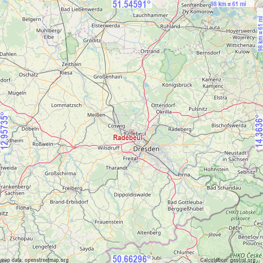
Radebeul GPS coordinates[2]
51° 6' 23.544" North, 13° 39' 37.692" East
| Map corner | latitude | longitude |
|---|---|---|
| Upper-left | 51.54591°, | 12.95735° |
| Center: | 51.10654°, | 13.66047° |
| Lower-right: | 50.66296°, | 14.3636° |
| Map W x H: | 98.2×98.2 km | = 61×61mi |
| max Lat: | 55.01917° ⇑40% North |
| Radebeul: | 51.10654° |
| min Lat: | ⇓60% South 47.40724° |
| min Long | Radebeul | max Long |
| 5.92978° | 13.66047° | 14.98853° |
| W 96.6%⇐ | ⇒3.4% E |
Elevation
Elevation of Radebeul is 120 m = 394 ft, and this is 129.1 m = 424 ft below average elevation for this country.
| Max E: |
1256 m = 4121 ft | 65% |
| Avg. | 249.1 m = 817 ft | |
| Radebeul | 120 m = 394 ft | |
Min E: |
-5 m = -16 ft | 35% |
See also: Germany elevation on elevation.city.
Geographical zone
Radebeul is located in North temperate zone (between Tropic of Cancer and the Arctic Circle). Distance of this North polar circle is 1718.7 km =1068 mi to North.| Distance of | km | miles | from Radebeul |
|---|---|---|---|
| North Pole | 4324.5 | 2687.1 | to North |
| Arctic Circle | 1718.7 | 1068 | to North |
| Tropic Cancer | 3076.6 | 1911.7 | to South |
| Equator | 5682.5 | 3530.9 | to South |


Nearby cities:
15 places around Radebeul: (largest is in red/bold)
• Albertstadt
7.9 km =4.9 mi,  109°
109°
• Bannewitz
13.2 km =8.2 mi,  162°
162°
• Coswig
6.1 km =3.8 mi,  297°
297°
• Dresden
8.2 km =5.1 mi,  138°
138°
• Ebersbach
14.1 km =8.8 mi,  357°
357°
• Freital
11.7 km =7.3 mi,  184°
184°
• Klipphausen
11.1 km =6.9 mi,  247°
247°
• Meissen
14.4 km =8.9 mi, 295°
• Moritzburg
6 km =3.7 mi,  13°
13°
• Niederau
11.2 km =7 mi,  314°
314°
• Ottendorf-Okrilla
14.8 km =9.2 mi,  54°
54°
• Radeburg
13 km =8.1 mi,  21°
21°
• Tharandt
14.6 km =9.1 mi,  202°
202°
• Weinböhla
9.4 km =5.8 mi,  315°
315°
• Wilsdruff
10.6 km =6.6 mi,  234°
234°
Sources, notices
• [Note1] Compared only with cities in Germany existing in our database
• [Src1] Map data: © OpenStreetMap contributors (CC-BY-SA)
• [Src2] Other city data from geonames.org with taken over terms of usage.
• [Src3] Geographical zone / Annual Mean Temperature by Robert A. Rohde @ Wikipedia
