Tharandt geodata
Tharandt (Saxony) is a seat of a third-order administrative division; located in Germany in Europe/Berlin (GMT+2) time zone. With population of 5,624 people, there are 2585 cities with bigger population in this country. Compared to other cities in Germany, 57.9% of cities are located further ↓South; 96.2% of cities are located further ←West and 50.7% of cities have lower elevation than Tharandt. Note1


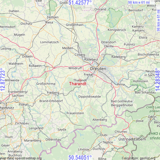
Tharandt GPS coordinates[2]
50° 59' 6.9" North, 13° 34' 49.26" East
| Map corner | latitude | longitude |
|---|---|---|
| Upper-left | 51.42577°, | 12.87723° |
| Center: | 50.98525°, | 13.58035° |
| Lower-right: | 50.54051°, | 14.28348° |
| Map W x H: | 98.4×98.4 km | = 61.1×61.1mi |
| max Lat: | 55.01917° ⇑42.1% North |
| Tharandt: | 50.98525° |
| min Lat: | ⇓57.9% South 47.40724° |
| min Long | Tharandt | max Long |
| 5.92978° | 13.58035° | 14.98853° |
| W 96.2%⇐ | ⇒3.8% E |
Elevation
Elevation of Tharandt is 231 m = 758 ft, and this is 18.1 m = 59 ft below average elevation for this country.
| Max E: |
1256 m = 4121 ft | 49.3% |
| Avg. | 249.1 m = 817 ft | |
| Tharandt | 231 m = 758 ft | |
Min E: |
-5 m = -16 ft | 50.7% |
See also: Germany elevation on elevation.city.
Geographical zone
Tharandt is located in North temperate zone (between Tropic of Cancer and the Arctic Circle). Distance of this North polar circle is 1732.1 km =1076.3 mi to North.| Distance of | km | miles | from Tharandt |
|---|---|---|---|
| North Pole | 4338 | 2695.5 | to North |
| Arctic Circle | 1732.1 | 1076.3 | to North |
| Tropic Cancer | 3063.1 | 1903.3 | to South |
| Equator | 5669 | 3522.6 | to South |


Nearby cities:
15 places around Tharandt: (largest is in red/bold)
• Bannewitz
9.6 km =6 mi,  84°
84°
• Dippoldiswalde
11.7 km =7.3 mi,  147°
147°
• Dorfhain
5.9 km =3.7 mi,  189°
189°
• Dresden
13.2 km =8.2 mi,  56°
56°
• Freital
5.1 km =3.2 mi,  69°
69°
• Hermsdorf
12.8 km =8 mi,  122°
122°
• Klipphausen
10.4 km =6.5 mi,  333°
333°
• Kreischa
13 km =8.1 mi,  109°
109°
• Niederschöna
11.5 km =7.1 mi,  259°
259°
• Obercunnersdorf
7.7 km =4.8 mi, 190°
• Pretzschendorf
13 km =8.1 mi,  197°
197°
• Rabenau
4.9 km =3 mi, 117°
• Radebeul
14.6 km =9.1 mi,  22°
22°
• Reinsberg
15.3 km =9.5 mi,  279°
279°
• Wilsdruff
8 km =5 mi,  337°
337°
Sources, notices
• [Note1] Compared only with cities in Germany existing in our database
• [Src1] Map data: © OpenStreetMap contributors (CC-BY-SA)
• [Src2] Other city data from geonames.org with taken over terms of usage.
• [Src3] Geographical zone / Annual Mean Temperature by Robert A. Rohde @ Wikipedia
