Wilsdruff geodata
Wilsdruff (Saxony) is a populated place; located in Germany in Europe/Berlin (GMT+2) time zone. With population of 13,772 people, there are 1162 cities with bigger population in this country. Compared to other cities in Germany, 59% of cities are located further ↓South; 96% of cities are located further ←West and 56.5% of cities have lower elevation than Wilsdruff. Note1
Administrative division(s):
- Level 1: Saxony
- Level 3: Landkreis Sächsische Schweiz
- Level 4: Wilsdruff


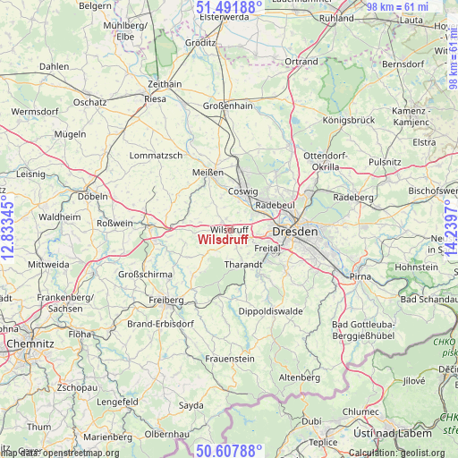
Wilsdruff GPS coordinates[2]
51° 3' 7.164" North, 13° 32' 11.652" East
| Map corner | latitude | longitude |
|---|---|---|
| Upper-left | 51.49188°, | 12.83345° |
| Center: | 51.05199°, | 13.53657° |
| Lower-right: | 50.60788°, | 14.2397° |
| Map W x H: | 98.3×98.3 km | = 61.1×61.1mi |
| max Lat: | 55.01917° ⇑41% North |
| Wilsdruff: | 51.05199° |
| min Lat: | ⇓59% South 47.40724° |
| min Long | Wilsdruff | max Long |
| 5.92978° | 13.53657° | 14.98853° |
| W 96%⇐ | ⇒4% E |
Elevation
Elevation of Wilsdruff is 269 m = 883 ft, and this is 19.9 m = 65 ft above average elevation for this country.
| Max E: |
1256 m = 4121 ft | 43.5% |
| Wilsdruff | 269 m 883 ft | |
| Avg. | 249.1 m = 817 ft | |
Min E: |
-5 m = -16 ft | 56.5% |
See also: Germany elevation on elevation.city.
Geographical zone
Wilsdruff is located in North temperate zone (between Tropic of Cancer and the Arctic Circle). Distance of this North polar circle is 1724.7 km =1071.7 mi to North.| Distance of | km | miles | from Wilsdruff |
|---|---|---|---|
| North Pole | 4330.6 | 2690.9 | to North |
| Arctic Circle | 1724.7 | 1071.7 | to North |
| Tropic Cancer | 3070.5 | 1907.9 | to South |
| Equator | 5676.4 | 3527.2 | to South |


Nearby cities:
15 places around Wilsdruff: (largest is in red/bold)
• Bannewitz
14.2 km =8.8 mi,  117°
117°
• Coswig
9.5 km =5.9 mi,  20°
20°
• Dorfhain
13.4 km =8.3 mi,  170°
170°
• Dresden
14.1 km =8.8 mi,  90°
90°
• Freital
9.6 km =6 mi,  125°
125°
• Klipphausen
2.4 km =1.5 mi,  318°
318°
• Meissen
13 km =8.1 mi,  340°
340°
• Niederau
13.9 km =8.6 mi,  2°
2°
• Niederschöna
12.5 km =7.8 mi,  220°
220°
• Obercunnersdorf
15.1 km =9.4 mi, 173°
• Rabenau
12.2 km =7.6 mi,  142°
142°
• Radebeul
10.6 km =6.6 mi,  54°
54°
• Reinsberg
12.9 km =8 mi,  247°
247°
• Tharandt
8 km =5 mi,  157°
157°
• Weinböhla
12.9 km =8 mi,  9°
9°
Sources, notices
• [Note1] Compared only with cities in Germany existing in our database
• [Src1] Map data: © OpenStreetMap contributors (CC-BY-SA)
• [Src2] Other city data from geonames.org with taken over terms of usage.
• [Src3] Geographical zone / Annual Mean Temperature by Robert A. Rohde @ Wikipedia
