Weinböhla geodata
Weinböhla (Saxony) is a seat of a fourth-order administrative division; located in Germany in Europe/Berlin (GMT+2) time zone. With population of 10,456 people, there are 1575 cities with bigger population in this country. Compared to other cities in Germany, 61% of cities are located further ↓South; 96.1% of cities are located further ←West and 62.2% of cities have higher elevation than Weinböhla. Note1


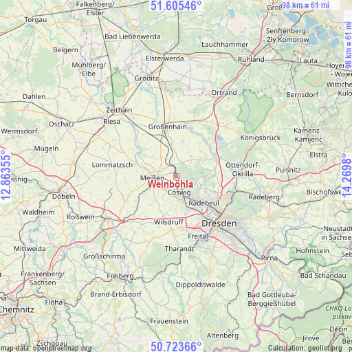
Weinböhla GPS coordinates[2]
51° 10' 0.012" North, 13° 34' 0.012" East
| Map corner | latitude | longitude |
|---|---|---|
| Upper-left | 51.60546°, | 12.86355° |
| Center: | 51.16667°, | 13.56667° |
| Lower-right: | 50.72366°, | 14.2698° |
| Map W x H: | 98×98 km | = 60.9×60.9mi |
| max Lat: | 55.01917° ⇑39% North |
| Weinböhla: | 51.16667° |
| min Lat: | ⇓61% South 47.40724° |
| min Long | Weinböhla | max Long |
| 5.92978° | 13.56667° | 14.98853° |
| W 96.1%⇐ | ⇒3.9% E |
Elevation
Elevation of Weinböhla is 137 m = 449 ft, and this is 112.1 m = 368 ft below average elevation for this country.
| Max E: |
1256 m = 4121 ft | 62.2% |
| Avg. | 249.1 m = 817 ft | |
| Weinböhla | 137 m = 449 ft | |
Min E: |
-5 m = -16 ft | 37.8% |
See also: Germany elevation on elevation.city.
Geographical zone
Weinböhla is located in North temperate zone (between Tropic of Cancer and the Arctic Circle). Distance of this North polar circle is 1712 km =1063.8 mi to North.| Distance of | km | miles | from Weinböhla |
|---|---|---|---|
| North Pole | 4317.9 | 2683 | to North |
| Arctic Circle | 1712 | 1063.8 | to North |
| Tropic Cancer | 3083.3 | 1915.9 | to South |
| Equator | 5689.2 | 3535.1 | to South |


Nearby cities:
15 places around Weinböhla: (largest is in red/bold)
• Albertstadt
16.8 km =10.4 mi,  123°
123°
• Coswig
4 km =2.5 mi,  163°
163°
• Ebersbach
9.4 km =5.8 mi,  38°
38°
• Großenhain
13.9 km =8.6 mi,  350°
350°
• Klipphausen
11.5 km =7.1 mi,  198°
198°
• Meissen
6.5 km =4 mi,  265°
265°
• Moritzburg
8 km =5 mi,  95°
95°
• Niederau
1.9 km =1.2 mi,  308°
308°
• Priestewitz
9.9 km =6.2 mi,  339°
339°
• Radebeul
9.4 km =5.8 mi,  135°
135°
• Radeburg
12.5 km =7.8 mi,  64°
64°
• Schönfeld
17.5 km =10.9 mi,  32°
32°
• Weißig
16.4 km =10.2 mi,  327°
327°
• Wildenhain
16.9 km =10.5 mi, 338°
• Wilsdruff
12.9 km =8 mi,  189°
189°
Sources, notices
• [Note1] Compared only with cities in Germany existing in our database
• [Src1] Map data: © OpenStreetMap contributors (CC-BY-SA)
• [Src2] Other city data from geonames.org with taken over terms of usage.
• [Src3] Geographical zone / Annual Mean Temperature by Robert A. Rohde @ Wikipedia
