Kleinniedesheim geodata
Kleinniedesheim (Rheinland-Pfalz) is a seat of a fourth-order administrative division; located in Germany in Europe/Berlin (GMT+2) time zone. With population of 922 people, there are 7450 cities with bigger population in this country. Compared to other cities in Germany, 74% of cities are located further ↑North; 72.7% of cities are located further →East and 69% of cities have higher elevation than Kleinniedesheim. Note1
Administrative division(s):
- Level 1: Rheinland-Pfalz
- Level 3: Rhein-Pfalz-Kreis
- Level 4: Kleinniedesheim


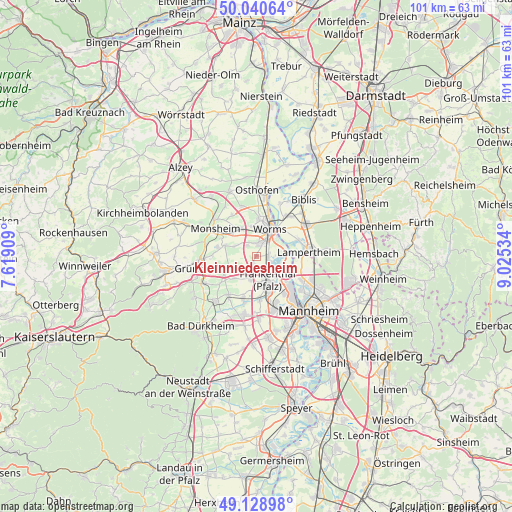
Kleinniedesheim GPS coordinates[2]
49° 35' 12.984" North, 8° 19' 19.992" East
| Map corner | latitude | longitude |
|---|---|---|
| Upper-left | 50.04064°, | 7.61909° |
| Center: | 49.58694°, | 8.32222° |
| Lower-right: | 49.12898°, | 9.02534° |
| Map W x H: | 101.4×101.4 km | = 63×63mi |
| max Lat: | 55.01917° ⇑74% North |
| Kleinniedesheim: | 49.58694° |
| min Lat: | ⇓26% South 47.40724° |
| min Long | Kleinniedesheim | max Long |
| 5.92978° | 8.32222° | 14.98853° |
| W 27.3%⇐ | ⇒72.7% E |
Elevation
Elevation of Kleinniedesheim is 97 m = 318 ft, and this is 152.1 m = 499 ft below average elevation for this country.
| Max E: |
1256 m = 4121 ft | 69% |
| Avg. | 249.1 m = 817 ft | |
| Kleinniedesheim | 97 m = 318 ft | |
Min E: |
-5 m = -16 ft | 31% |
See also: Germany elevation on elevation.city.
Geographical zone
Kleinniedesheim is located in North temperate zone (between Tropic of Cancer and the Arctic Circle). Distance of this North polar circle is 1887.6 km =1172.9 mi to North.| Distance of | km | miles | from Kleinniedesheim |
|---|---|---|---|
| North Pole | 4493.5 | 2792.1 | to North |
| Arctic Circle | 1887.6 | 1172.9 | to North |
| Tropic Cancer | 2907.6 | 1806.7 | to South |
| Equator | 5513.6 | 3426 | to South |


Nearby cities:
15 places around Kleinniedesheim: (largest is in red/bold)
• Beindersheim
2.9 km =1.8 mi,  183°
183°
• Bobenheim-Roxheim
2.6 km =1.6 mi,  88°
88°
• Dirmstein
6.2 km =3.9 mi,  244°
244°
• Frankenthal
6.3 km =3.9 mi,  158°
158°
• Gerolsheim
6.1 km =3.8 mi,  224°
224°
• Großniedesheim
1.5 km =0.9 mi,  209°
209°
• Heuchelheim bei Frankenthal
3.5 km =2.2 mi, 220°
• Heßheim
4.7 km =2.9 mi,  192°
192°
• Hohen-Sülzen
7.8 km =4.8 mi,  297°
297°
• Lambsheim
8.5 km =5.3 mi,  196°
196°
• Laumersheim
7.3 km =4.5 mi, 239°
• Obersülzen
8.3 km =5.2 mi,  255°
255°
• Obrigheim
8.5 km =5.3 mi,  273°
273°
• Offstein
6.4 km =4 mi,  289°
289°
• Worms
5.7 km =3.5 mi,  27°
27°
Sources, notices
• [Note1] Compared only with cities in Germany existing in our database
• [Src1] Map data: © OpenStreetMap contributors (CC-BY-SA)
• [Src2] Other city data from geonames.org with taken over terms of usage.
• [Src3] Geographical zone / Annual Mean Temperature by Robert A. Rohde @ Wikipedia
