Heßheim geodata
Heßheim (Rheinland-Pfalz) is a seat of a fourth-order administrative division; located in Germany in Europe/Berlin (GMT+2) time zone. With population of 3,044 people, there are 3969 cities with bigger population in this country. Compared to other cities in Germany, 74.9% of cities are located further ↑North; 72.8% of cities are located further →East and 68.3% of cities have higher elevation than Heßheim. Note1


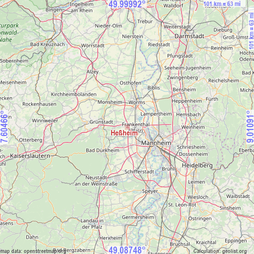
Heßheim GPS coordinates[2]
49° 32' 44.988" North, 8° 18' 28.008" East
| Map corner | latitude | longitude |
|---|---|---|
| Upper-left | 49.99992°, | 7.60466° |
| Center: | 49.54583°, | 8.30778° |
| Lower-right: | 49.08748°, | 9.01091° |
| Map W x H: | 101.5×101.5 km | = 63.1×63.1mi |
| max Lat: | 55.01917° ⇑74.9% North |
| Heßheim: | 49.54583° |
| min Lat: | ⇓25.1% South 47.40724° |
| min Long | Heßheim | max Long |
| 5.92978° | 8.30778° | 14.98853° |
| W 27.2%⇐ | ⇒72.8% E |
Elevation
Elevation of Heßheim is 101 m = 331 ft, and this is 148.1 m = 486 ft below average elevation for this country.
| Max E: |
1256 m = 4121 ft | 68.3% |
| Avg. | 249.1 m = 817 ft | |
| Heßheim | 101 m = 331 ft | |
Min E: |
-5 m = -16 ft | 31.7% |
See also: Germany elevation on elevation.city.
Geographical zone
Heßheim is located in North temperate zone (between Tropic of Cancer and the Arctic Circle). Distance of this North polar circle is 1892.2 km =1175.8 mi to North.| Distance of | km | miles | from Heßheim |
|---|---|---|---|
| North Pole | 4498.1 | 2795 | to North |
| Arctic Circle | 1892.2 | 1175.8 | to North |
| Tropic Cancer | 2903.1 | 1803.9 | to South |
| Equator | 5509 | 3423.1 | to South |


Nearby cities:
15 places around Heßheim: (largest is in red/bold)
• Beindersheim
1.8 km =1.1 mi,  27°
27°
• Bissersheim
7.6 km =4.7 mi,  261°
261°
• Bobenheim-Roxheim
5.9 km =3.7 mi,  37°
37°
• Dirmstein
4.9 km =3 mi,  293°
293°
• Frankenthal
3.6 km =2.2 mi,  111°
111°
• Gerolsheim
3.2 km =2 mi,  273°
273°
• Großkarlbach
6.1 km =3.8 mi, 262°
• Großniedesheim
3.3 km =2.1 mi,  5°
5°
• Heuchelheim bei Frankenthal
2.3 km =1.4 mi,  327°
327°
• Kleinniedesheim
4.7 km =2.9 mi, 12°
• Lambsheim
3.9 km =2.4 mi,  201°
201°
• Laumersheim
5.3 km =3.3 mi,  279°
279°
• Maxdorf
6.5 km =4 mi,  190°
190°
• Obersülzen
7.4 km =4.6 mi, 289°
• Weisenheim am Sand
5.3 km =3.3 mi,  234°
234°
Sources, notices
• [Note1] Compared only with cities in Germany existing in our database
• [Src1] Map data: © OpenStreetMap contributors (CC-BY-SA)
• [Src2] Other city data from geonames.org with taken over terms of usage.
• [Src3] Geographical zone / Annual Mean Temperature by Robert A. Rohde @ Wikipedia
