Gerolsheim geodata
Gerolsheim (Rheinland-Pfalz) is a seat of a fourth-order administrative division; located in Germany in Europe/Berlin (GMT+2) time zone. With population of 1,684 people, there are 5541 cities with bigger population in this country. Compared to other cities in Germany, 74.9% of cities are located further ↑North; 73.3% of cities are located further →East and 67.3% of cities have higher elevation than Gerolsheim. Note1
Administrative division(s):
- Level 1: Rheinland-Pfalz
- Level 3: Landkreis Bad Dürkheim
- Level 4: Gerolsheim


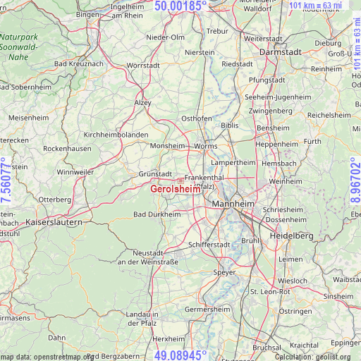
Gerolsheim GPS coordinates[2]
49° 32' 52.008" North, 8° 15' 50.004" East
| Map corner | latitude | longitude |
|---|---|---|
| Upper-left | 50.00185°, | 7.56077° |
| Center: | 49.54778°, | 8.26389° |
| Lower-right: | 49.08945°, | 8.96702° |
| Map W x H: | 101.4×101.4 km | = 63×63mi |
| max Lat: | 55.01917° ⇑74.9% North |
| Gerolsheim: | 49.54778° |
| min Lat: | ⇓25.1% South 47.40724° |
| min Long | Gerolsheim | max Long |
| 5.92978° | 8.26389° | 14.98853° |
| W 26.7%⇐ | ⇒73.3% E |
Elevation
Elevation of Gerolsheim is 106 m = 348 ft, and this is 143.1 m = 469 ft below average elevation for this country.
| Max E: |
1256 m = 4121 ft | 67.3% |
| Avg. | 249.1 m = 817 ft | |
| Gerolsheim | 106 m = 348 ft | |
Min E: |
-5 m = -16 ft | 32.7% |
See also: Germany elevation on elevation.city.
Geographical zone
Gerolsheim is located in North temperate zone (between Tropic of Cancer and the Arctic Circle). Distance of this North polar circle is 1892 km =1175.6 mi to North.| Distance of | km | miles | from Gerolsheim |
|---|---|---|---|
| North Pole | 4497.9 | 2794.9 | to North |
| Arctic Circle | 1892 | 1175.6 | to North |
| Tropic Cancer | 2903.3 | 1804 | to South |
| Equator | 5509.2 | 3423.3 | to South |


Nearby cities:
15 places around Gerolsheim: (largest is in red/bold)
• Beindersheim
4.3 km =2.7 mi,  70°
70°
• Bissersheim
4.5 km =2.8 mi,  252°
252°
• Dackenheim
6.3 km =3.9 mi,  241°
241°
• Dirmstein
2.2 km =1.4 mi,  321°
321°
• Freinsheim
5.9 km =3.7 mi,  219°
219°
• Großkarlbach
3 km =1.9 mi, 249°
• Großniedesheim
4.6 km =2.9 mi,  48°
48°
• Heuchelheim bei Frankenthal
2.6 km =1.6 mi, 48°
• Heßheim
3.2 km =2 mi,  93°
93°
• Kirchheim an der Weinstraße
6.1 km =3.8 mi,  258°
258°
• Kleinniedesheim
6.1 km =3.8 mi,  44°
44°
• Lambsheim
4.2 km =2.6 mi,  155°
155°
• Laumersheim
2.2 km =1.4 mi,  288°
288°
• Obersülzen
4.4 km =2.7 mi,  301°
301°
• Weisenheim am Sand
3.5 km =2.2 mi,  199°
199°
Sources, notices
• [Note1] Compared only with cities in Germany existing in our database
• [Src1] Map data: © OpenStreetMap contributors (CC-BY-SA)
• [Src2] Other city data from geonames.org with taken over terms of usage.
• [Src3] Geographical zone / Annual Mean Temperature by Robert A. Rohde @ Wikipedia
