Laumersheim geodata
Laumersheim (Rheinland-Pfalz) is a seat of a fourth-order administrative division; located in Germany in Europe/Berlin (GMT+2) time zone. With population of 889 people, there are 7565 cities with bigger population in this country. Compared to other cities in Germany, 74.7% of cities are located further ↑North; 73.7% of cities are located further →East and 66.7% of cities have higher elevation than Laumersheim. Note1
Administrative division(s):
- Level 1: Rheinland-Pfalz
- Level 3: Landkreis Bad Dürkheim
- Level 4: Laumersheim


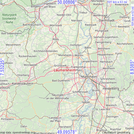
Laumersheim GPS coordinates[2]
49° 33' 14.58" North, 8° 14' 7.368" East
| Map corner | latitude | longitude |
|---|---|---|
| Upper-left | 50.00806°, | 7.53225° |
| Center: | 49.55405°, | 8.23538° |
| Lower-right: | 49.09578°, | 8.9385° |
| Map W x H: | 101.4×101.4 km | = 63×63mi |
| max Lat: | 55.01917° ⇑74.7% North |
| Laumersheim: | 49.55405° |
| min Lat: | ⇓25.3% South 47.40724° |
| min Long | Laumersheim | max Long |
| 5.92978° | 8.23538° | 14.98853° |
| W 26.3%⇐ | ⇒73.7% E |
Elevation
Elevation of Laumersheim is 110 m = 361 ft, and this is 139.1 m = 456 ft below average elevation for this country.
| Max E: |
1256 m = 4121 ft | 66.7% |
| Avg. | 249.1 m = 817 ft | |
| Laumersheim | 110 m = 361 ft | |
Min E: |
-5 m = -16 ft | 33.3% |
See also: Germany elevation on elevation.city.
Geographical zone
Laumersheim is located in North temperate zone (between Tropic of Cancer and the Arctic Circle). Distance of this North polar circle is 1891.3 km =1175.2 mi to North.| Distance of | km | miles | from Laumersheim |
|---|---|---|---|
| North Pole | 4497.2 | 2794.4 | to North |
| Arctic Circle | 1891.3 | 1175.2 | to North |
| Tropic Cancer | 2904 | 1804.5 | to South |
| Equator | 5509.9 | 3423.7 | to South |


Nearby cities:
15 places around Laumersheim: (largest is in red/bold)
• Bissersheim
3 km =1.9 mi,  228°
228°
• Dackenheim
5 km =3.1 mi,  223°
223°
• Dirmstein
1.2 km =0.7 mi,  33°
33°
• Freinsheim
5.6 km =3.5 mi,  197°
197°
• Gerolsheim
2.2 km =1.4 mi,  108°
108°
• Großkarlbach
1.9 km =1.2 mi, 203°
• Grünstadt
5.3 km =3.3 mi,  280°
280°
• Heidesheim
4.3 km =2.7 mi,  317°
317°
• Heuchelheim bei Frankenthal
4.1 km =2.5 mi,  75°
75°
• Heßheim
5.3 km =3.3 mi,  99°
99°
• Kirchheim an der Weinstraße
4.4 km =2.7 mi,  244°
244°
• Obersülzen
2.3 km =1.4 mi,  312°
312°
• Obrigheim
4.7 km =2.9 mi,  332°
332°
• Offstein
5.8 km =3.6 mi,  1°
1°
• Weisenheim am Sand
4.1 km =2.5 mi,  167°
167°
Sources, notices
• [Note1] Compared only with cities in Germany existing in our database
• [Src1] Map data: © OpenStreetMap contributors (CC-BY-SA)
• [Src2] Other city data from geonames.org with taken over terms of usage.
• [Src3] Geographical zone / Annual Mean Temperature by Robert A. Rohde @ Wikipedia
