Frankenthal geodata
Frankenthal (Rheinland-Pfalz) is a seat of a third-order administrative division; located in Germany in Europe/Berlin (GMT+2) time zone. With population of 47,438 people, there are 245 cities with bigger population in this country. Compared to other cities in Germany, 75.1% of cities are located further ↑North; 72.3% of cities are located further →East and 68.7% of cities have higher elevation than Frankenthal. Note1
Administrative division(s):
- Level 1: Rheinland-Pfalz
- Level 3: Kreisfreie Stadt Frankenthal (Pfalz)
- Level 4: Frankenthal (Pfalz)


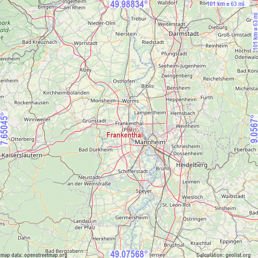
Frankenthal GPS coordinates[2]
49° 32' 2.904" North, 8° 21' 12.852" East
| Map corner | latitude | longitude |
|---|---|---|
| Upper-left | 49.98834°, | 7.65045° |
| Center: | 49.53414°, | 8.35357° |
| Lower-right: | 49.07568°, | 9.0567° |
| Map W x H: | 101.5×101.5 km | = 63.1×63.1mi |
| max Lat: | 55.01917° ⇑75.1% North |
| Frankenthal: | 49.53414° |
| min Lat: | ⇓24.9% South 47.40724° |
| min Long | Frankenthal | max Long |
| 5.92978° | 8.35357° | 14.98853° |
| W 27.7%⇐ | ⇒72.3% E |
Elevation
Elevation of Frankenthal is 99 m = 325 ft, and this is 150.1 m = 492 ft below average elevation for this country.
| Max E: |
1256 m = 4121 ft | 68.7% |
| Avg. | 249.1 m = 817 ft | |
| Frankenthal | 99 m = 325 ft | |
Min E: |
-5 m = -16 ft | 31.3% |
See also: Frankenthal elevation on elevation.city.
Geographical zone
Frankenthal is located in North temperate zone (between Tropic of Cancer and the Arctic Circle). Distance of this North polar circle is 1893.5 km =1176.6 mi to North.| Distance of | km | miles | from Frankenthal |
|---|---|---|---|
| North Pole | 4499.4 | 2795.8 | to North |
| Arctic Circle | 1893.5 | 1176.6 | to North |
| Tropic Cancer | 2901.8 | 1803.1 | to South |
| Equator | 5507.7 | 3422.3 | to South |


Nearby cities:
15 places around Frankenthal: (largest is in red/bold)
• Beindersheim
3.8 km =2.4 mi,  320°
320°
• Birkenheide
8.8 km =5.5 mi,  228°
228°
• Bobenheim-Roxheim
5.9 km =3.7 mi,  2°
2°
• Dirmstein
8.5 km =5.3 mi,  292°
292°
• Gartenstadt
9.1 km =5.7 mi,  156°
156°
• Gerolsheim
6.6 km =4.1 mi,  283°
283°
• Großniedesheim
5.5 km =3.4 mi,  326°
326°
• Heuchelheim bei Frankenthal
5.6 km =3.5 mi,  305°
305°
• Heßheim
3.6 km =2.2 mi, 291°
• Kleinniedesheim
6.3 km =3.9 mi,  338°
338°
• Lambsheim
5.3 km =3.3 mi,  244°
244°
• Laumersheim
8.8 km =5.5 mi, 284°
• Ludwigshafen am Rhein
8.9 km =5.5 mi,  131°
131°
• Maxdorf
6.8 km =4.2 mi,  221°
221°
• Weisenheim am Sand
7.8 km =4.8 mi,  256°
256°
Sources, notices
• [Note1] Compared only with cities in Germany existing in our database
• [Src1] Map data: © OpenStreetMap contributors (CC-BY-SA)
• [Src2] Other city data from geonames.org with taken over terms of usage.
• [Src3] Geographical zone / Annual Mean Temperature by Robert A. Rohde @ Wikipedia
