Lambsheim geodata
Lambsheim (Rheinland-Pfalz) is a seat of a fourth-order administrative division; located in Germany in Europe/Berlin (GMT+2) time zone. With population of 6,104 people, there are 2429 cities with bigger population in this country. Compared to other cities in Germany, 75.5% of cities are located further ↑North; 73% of cities are located further →East and 68% of cities have higher elevation than Lambsheim. Note1


Lambsheim GPS coordinates[2]
49° 30' 48.996" North, 8° 17' 16.008" East
| Map corner | latitude | longitude |
|---|---|---|
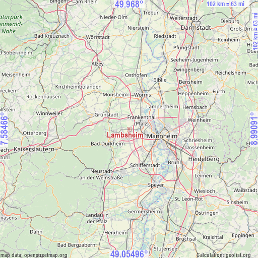
| Upper-left | 49.968°, | 7.58466° |
| Center: | 49.51361°, | 8.28778° |
| Lower-right: | 49.05496°, | 8.99091° |
| Map W x H: | 101.5×101.5 km | = 63.1×63.1mi |
| max Lat: | 55.01917° ⇑75.5% North |
| Lambsheim: | 49.51361° |
| min Lat: | ⇓24.5% South 47.40724° |
| min Long | Lambsheim | max Long |
| 5.92978° | 8.28778° | 14.98853° |
| W 27%⇐ | ⇒73% E |
Elevation
Elevation of Lambsheim is 102 m = 335 ft, and this is 147.1 m = 483 ft below average elevation for this country.
| Max E: |
1256 m = 4121 ft | 68% |
| Avg. | 249.1 m = 817 ft | |
| Lambsheim | 102 m = 335 ft | |
Min E: |
-5 m = -16 ft | 32% |
See also: Germany elevation on elevation.city.
Geographical zone
Lambsheim is located in North temperate zone (between Tropic of Cancer and the Arctic Circle). Distance of this North polar circle is 1895.8 km =1178 mi to North.| Distance of | km | miles | from Lambsheim |
|---|---|---|---|
| North Pole | 4501.7 | 2797.2 | to North |
| Arctic Circle | 1895.8 | 1178 | to North |
| Tropic Cancer | 2899.5 | 1801.7 | to South |
| Equator | 5505.4 | 3420.9 | to South |


Nearby cities:
15 places around Lambsheim: (largest is in red/bold)
• Beindersheim
5.7 km =3.5 mi,  23°
23°
• Birkenheide
4 km =2.5 mi,  207°
207°
• Dirmstein
6.3 km =3.9 mi,  330°
330°
• Ellerstadt
6.1 km =3.8 mi,  199°
199°
• Erpolzheim
5.3 km =3.3 mi,  239°
239°
• Frankenthal
5.3 km =3.3 mi,  64°
64°
• Freinsheim
5.5 km =3.4 mi,  261°
261°
• Fußgönheim
5.8 km =3.6 mi,  176°
176°
• Gerolsheim
4.2 km =2.6 mi,  335°
335°
• Großkarlbach
5.3 km =3.3 mi,  301°
301°
• Heuchelheim bei Frankenthal
5.5 km =3.4 mi,  2°
2°
• Heßheim
3.9 km =2.4 mi, 21°
• Laumersheim
5.9 km =3.7 mi,  319°
319°
• Maxdorf
2.9 km =1.8 mi,  174°
174°
• Weisenheim am Sand
2.9 km =1.8 mi,  279°
279°
Sources, notices
• [Note1] Compared only with cities in Germany existing in our database
• [Src1] Map data: © OpenStreetMap contributors (CC-BY-SA)
• [Src2] Other city data from geonames.org with taken over terms of usage.
• [Src3] Geographical zone / Annual Mean Temperature by Robert A. Rohde @ Wikipedia
