Sulza geodata
Sulza (Thuringia) is a seat of a fourth-order administrative division; located in Germany in Europe/Berlin (GMT+2) time zone. With population of 316 people, there are 9998 cities with bigger population in this country. Compared to other cities in Germany, 55.4% of cities are located further ↓South; 76% of cities are located further ←West and 51.2% of cities have higher elevation than Sulza. Note1


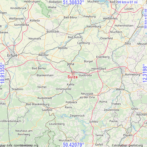
Sulza GPS coordinates[2]
50° 52' 0.012" North, 11° 37' 0.012" East
| Map corner | latitude | longitude |
|---|---|---|
| Upper-left | 51.30832°, | 10.91355° |
| Center: | 50.86667°, | 11.61667° |
| Lower-right: | 50.42079°, | 12.3198° |
| Map W x H: | 98.7×98.7 km | = 61.3×61.3mi |
| max Lat: | 55.01917° ⇑44.6% North |
| Sulza: | 50.86667° |
| min Lat: | ⇓55.4% South 47.40724° |
| min Long | Sulza | max Long |
| 5.92978° | 11.61667° | 14.98853° |
| W 76%⇐ | ⇒24% E |
Elevation
Elevation of Sulza is 217 m = 712 ft, and this is 32.1 m = 105 ft below average elevation for this country.
| Max E: |
1256 m = 4121 ft | 51.2% |
| Avg. | 249.1 m = 817 ft | |
| Sulza | 217 m = 712 ft | |
Min E: |
-5 m = -16 ft | 48.8% |
See also: Germany elevation on elevation.city.
Geographical zone
Sulza is located in North temperate zone (between Tropic of Cancer and the Arctic Circle). Distance of this North polar circle is 1745.3 km =1084.5 mi to North.| Distance of | km | miles | from Sulza |
|---|---|---|---|
| North Pole | 4351.2 | 2703.7 | to North |
| Arctic Circle | 1745.3 | 1084.5 | to North |
| Tropic Cancer | 3049.9 | 1895.1 | to South |
| Equator | 5655.8 | 3514.4 | to South |


Nearby cities:
15 places around Sulza: (largest is in red/bold)
• Altenberga
6.9 km =4.3 mi,  237°
237°
• Bucha
7.3 km =4.5 mi,  284°
284°
• Gneus
7.3 km =4.5 mi,  139°
139°
• Großbockedra
3 km =1.9 mi,  128°
128°
• Großpürschütz
5.7 km =3.5 mi,  191°
191°
• Jena
7.2 km =4.5 mi,  344°
344°
• Kahla
7 km =4.3 mi,  198°
198°
• Kleinbockedra
3 km =1.9 mi, 128°
• Laasdorf
4 km =2.5 mi,  82°
82°
• Rausdorf
4.7 km =2.9 mi,  90°
90°
• Rothenstein
2.2 km =1.4 mi,  212°
212°
• Schlöben
5.9 km =3.7 mi,  59°
59°
• Schöps
3.9 km =2.4 mi, 197°
• Unterbodnitz
6 km =3.7 mi,  157°
157°
• Zöllnitz
1.9 km =1.2 mi,  66°
66°
Sources, notices
• [Note1] Compared only with cities in Germany existing in our database
• [Src1] Map data: © OpenStreetMap contributors (CC-BY-SA)
• [Src2] Other city data from geonames.org with taken over terms of usage.
• [Src3] Geographical zone / Annual Mean Temperature by Robert A. Rohde @ Wikipedia
