Romrod geodata
Romrod (Hesse) is a populated place; located in Germany in Europe/Berlin (GMT+2) time zone. With population of 3,073 people, there are 3939 cities with bigger population in this country. Compared to other cities in Germany, 52.4% of cities are located further ↓South; 62% of cities are located further →East and 63.3% of cities have lower elevation than Romrod. Note1
Administrative division(s):
- Level 1: Hesse
- Level 2: Regierungsbezirk Gießen
- Level 3: Vogelsbergkreis
- Level 4: Romrod


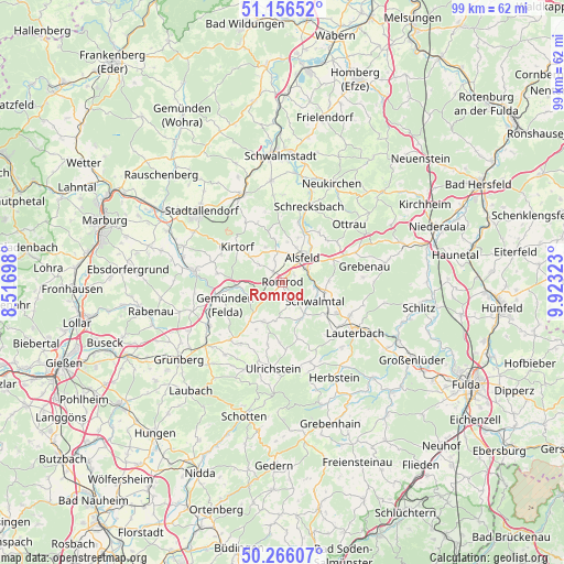
Romrod GPS coordinates[2]
50° 42' 48.276" North, 9° 13' 12.36" East
| Map corner | latitude | longitude |
|---|---|---|
| Upper-left | 51.15652°, | 8.51698° |
| Center: | 50.71341°, | 9.2201° |
| Lower-right: | 50.26607°, | 9.92323° |
| Map W x H: | 99×99 km | = 61.5×61.5mi |
| max Lat: | 55.01917° ⇑47.6% North |
| Romrod: | 50.71341° |
| min Lat: | ⇓52.4% South 47.40724° |
| min Long | Romrod | max Long |
| 5.92978° | 9.2201° | 14.98853° |
| W 38%⇐ | ⇒62% E |
Elevation
Elevation of Romrod is 310 m = 1017 ft, and this is 60.9 m = 200 ft above average elevation for this country.
| Max E: |
1256 m = 4121 ft | 36.7% |
| Romrod | 310 m 1017 ft | |
| Avg. | 249.1 m = 817 ft | |
Min E: |
-5 m = -16 ft | 63.3% |
See also: Germany elevation on elevation.city.
Geographical zone
Romrod is located in North temperate zone (between Tropic of Cancer and the Arctic Circle). Distance of this North polar circle is 1762.4 km =1095.1 mi to North.| Distance of | km | miles | from Romrod |
|---|---|---|---|
| North Pole | 4368.3 | 2714.3 | to North |
| Arctic Circle | 1762.4 | 1095.1 | to North |
| Tropic Cancer | 3032.9 | 1884.6 | to South |
| Equator | 5638.8 | 3503.8 | to South |


Nearby cities:
15 places around Romrod: (largest is in red/bold)
• Alsfeld
5.6 km =3.5 mi,  39°
39°
• Grebenau
18.1 km =11.2 mi,  79°
79°
• Herbstein
19.1 km =11.9 mi,  152°
152°
• Homberg
15.9 km =9.9 mi,  277°
277°
• Kirtorf
10.3 km =6.4 mi,  307°
307°
• Lauterbach
15.2 km =9.4 mi,  124°
124°
• Lautertal
15.1 km =9.4 mi,  162°
162°
• Neustadt (Hessen)
16.8 km =10.4 mi,  334°
334°
• Niederklein
18.1 km =11.2 mi,  299°
299°
• Ottrau
15.5 km =9.6 mi,  48°
48°
• Schrecksbach
14.1 km =8.8 mi,  18°
18°
• Schwalmtal
3.4 km =2.1 mi,  184°
184°
• Stadtallendorf
19 km =11.8 mi, 309°
• Ulrichstein
15.5 km =9.6 mi,  187°
187°
• Willingshausen
15.3 km =9.5 mi,  354°
354°
Sources, notices
• [Note1] Compared only with cities in Germany existing in our database
• [Src1] Map data: © OpenStreetMap contributors (CC-BY-SA)
• [Src2] Other city data from geonames.org with taken over terms of usage.
• [Src3] Geographical zone / Annual Mean Temperature by Robert A. Rohde @ Wikipedia
