Saarhölzbach geodata
Saarhölzbach (Saarland) is a populated place; located in Germany in Europe/Berlin (GMT+2) time zone. With population of 1,737 people, there are 5447 cities with bigger population in this country. Compared to other cities in Germany, 75.4% of cities are located further ↑North; 97% of cities are located further →East and 57.8% of cities have higher elevation than Saarhölzbach. Note1


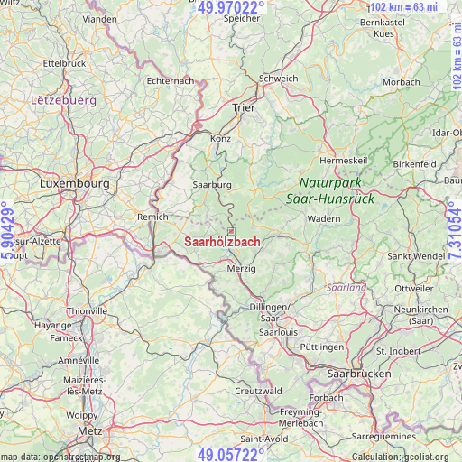
Saarhölzbach GPS coordinates[2]
49° 30' 57.06" North, 6° 36' 26.712" East
| Map corner | latitude | longitude |
|---|---|---|
| Upper-left | 49.97022°, | 5.90429° |
| Center: | 49.51585°, | 6.60742° |
| Lower-right: | 49.05722°, | 7.31054° |
| Map W x H: | 101.5×101.5 km | = 63.1×63.1mi |
| max Lat: | 55.01917° ⇑75.4% North |
| Saarhölzbach: | 49.51585° |
| min Lat: | ⇓24.6% South 47.40724° |
| min Long | Saarhölzbach | max Long |
| 5.92978° | 6.60742° | 14.98853° |
| W 3%⇐ | ⇒97% E |
Elevation
Elevation of Saarhölzbach is 169 m = 554 ft, and this is 80.1 m = 263 ft below average elevation for this country.
| Max E: |
1256 m = 4121 ft | 57.8% |
| Avg. | 249.1 m = 817 ft | |
| Saarhölzbach | 169 m = 554 ft | |
Min E: |
-5 m = -16 ft | 42.2% |
See also: Germany elevation on elevation.city.
Geographical zone
Saarhölzbach is located in North temperate zone (between Tropic of Cancer and the Arctic Circle). Distance of this North polar circle is 1895.5 km =1177.8 mi to North.| Distance of | km | miles | from Saarhölzbach |
|---|---|---|---|
| North Pole | 4501.4 | 2797 | to North |
| Arctic Circle | 1895.5 | 1177.8 | to North |
| Tropic Cancer | 2899.7 | 1801.8 | to South |
| Equator | 5505.6 | 3421 | to South |


Nearby cities:
15 places around Saarhölzbach: (largest is in red/bold)
• Britten
5 km =3.1 mi,  83°
83°
• Freudenburg
6.2 km =3.9 mi,  299°
299°
• Greimerath
7.5 km =4.7 mi,  47°
47°
• Irsch
9.9 km =6.2 mi,  355°
355°
• Kastel-Staadt
6.5 km =4 mi,  327°
327°
• Kirf
9.7 km =6 mi,  292°
292°
• Losheim
10 km =6.2 mi,  93°
93°
• Merzig
8.4 km =5.2 mi,  164°
164°
• Mettlach
2.8 km =1.7 mi,  214°
214°
• Orscholz
6.1 km =3.8 mi,  259°
259°
• Serrig
7 km =4.3 mi,  340°
340°
• Taben-Rodt
4.2 km =2.6 mi, 335°
• Trassem
9.1 km =5.7 mi,  319°
319°
• Weiten
5.1 km =3.2 mi, 288°
• Zerf
10.8 km =6.7 mi,  30°
30°
Sources, notices
• [Note1] Compared only with cities in Germany existing in our database
• [Src1] Map data: © OpenStreetMap contributors (CC-BY-SA)
• [Src2] Other city data from geonames.org with taken over terms of usage.
• [Src3] Geographical zone / Annual Mean Temperature by Robert A. Rohde @ Wikipedia
