Travemünde geodata
Travemünde (Schleswig-Holstein) is a section of populated place; located in Germany in Europe/Berlin (GMT+2) time zone. With population of 13,902 people, there are 1146 cities with bigger population in this country. Compared to other cities in Germany, 92.2% of cities are located further ↓South; 65.1% of cities are located further ←West and 96.6% of cities have higher elevation than Travemünde. Note1
Administrative division(s):
- Level 1: Schleswig-Holstein
- Level 3: Kreisfreie Stadt Lübeck
- Level 4: Lübeck, Hansestadt


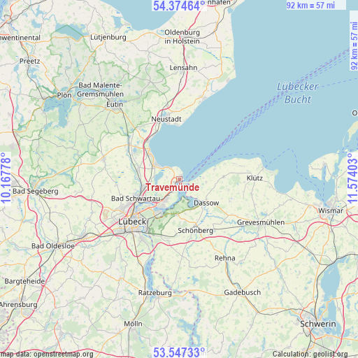
Travemünde GPS coordinates[2]
53° 57' 46.944" North, 10° 52' 15.24" East
| Map corner | latitude | longitude |
|---|---|---|
| Upper-left | 54.37464°, | 10.16778° |
| Center: | 53.96304°, | 10.8709° |
| Lower-right: | 53.54733°, | 11.57403° |
| Map W x H: | 92×92 km | = 57.2×57.2mi |
| max Lat: | 55.01917° ⇑7.8% North |
| Travemünde: | 53.96304° |
| min Lat: | ⇓92.2% South 47.40724° |
| min Long | Travemünde | max Long |
| 5.92978° | 10.8709° | 14.98853° |
| W 65.1%⇐ | ⇒34.9% E |
Elevation
Elevation of Travemünde is 5 m = 16 ft, and this is 244.1 m = 801 ft below average elevation for this country.
| Max E: |
1256 m = 4121 ft | 96.6% |
| Avg. | 249.1 m = 817 ft | |
| Travemünde | 5 m = 16 ft | |
Min E: |
-5 m = -16 ft | 3.4% |
See also: Germany elevation on elevation.city.
Geographical zone
Travemünde is located in North temperate zone (between Tropic of Cancer and the Arctic Circle). Distance of this North polar circle is 1401 km =870.5 mi to North.| Distance of | km | miles | from Travemünde |
|---|---|---|---|
| North Pole | 4006.9 | 2489.8 | to North |
| Arctic Circle | 1401 | 870.5 | to North |
| Tropic Cancer | 3394.2 | 2109.1 | to South |
| Equator | 6000.1 | 3728.3 | to South |


Nearby cities:
15 places around Travemünde: (largest is in red/bold)
• Bad Schwartau
12.4 km =7.7 mi,  246°
246°
• Dassow
9 km =5.6 mi,  130°
130°
• Elmenhorst
16.9 km =10.5 mi,  78°
78°
• Kalkhorst
11.4 km =7.1 mi,  86°
86°
• Lübeck
15.9 km =9.9 mi,  228°
228°
• Mallentin
16.2 km =10.1 mi,  123°
123°
• Neustadt in Holstein
16.4 km =10.2 mi,  347°
347°
• Pötenitz
3.8 km =2.4 mi,  114°
114°
• Ratekau
9.1 km =5.7 mi,  260°
260°
• Scharbeutz
11.1 km =6.9 mi,  314°
314°
• Selmsdorf
9 km =5.6 mi,  184°
184°
• Sierksdorf
13.4 km =8.3 mi,  329°
329°
• Stockelsdorf
16.6 km =10.3 mi,  241°
241°
• Süsel
17.2 km =10.7 mi,  319°
319°
• Timmendorfer Strand
7.1 km =4.4 mi,  300°
300°
In other languages:
- In German: Lübeck-Travemünde, Travemünde
- In Russian: Травемюнде
- In Chinese: 特拉弗明德
Sources, notices
• [Note1] Compared only with cities in Germany existing in our database
• [Src1] Map data: © OpenStreetMap contributors (CC-BY-SA)
• [Src2] Other city data from geonames.org with taken over terms of usage.
• [Src3] Geographical zone / Annual Mean Temperature by Robert A. Rohde @ Wikipedia
