Jungingen geodata
Jungingen (Baden-Württemberg) is a seat of a fourth-order administrative division; located in Germany in Europe/Berlin (GMT+2) time zone. With population of 1,469 people, there are 5941 cities with bigger population in this country. Compared to other cities in Germany, 91% of cities are located further ↑North; 64.9% of cities are located further →East and 94.6% of cities have lower elevation than Jungingen. Note1
Administrative division(s):
- Level 1: Baden-Württemberg
- Level 2: Tübingen Region
- Level 3: Zollernalbkreis
- Level 4: Jungingen


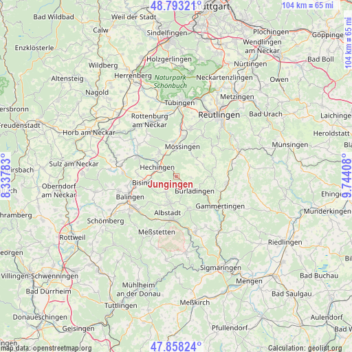
Jungingen GPS coordinates[2]
48° 19' 40.332" North, 9° 2' 27.42" East
| Map corner | latitude | longitude |
|---|---|---|
| Upper-left | 48.79321°, | 8.33783° |
| Center: | 48.32787°, | 9.04095° |
| Lower-right: | 47.85824°, | 9.74408° |
| Map W x H: | 104×104 km | = 64.6×64.6mi |
| max Lat: | 55.01917° ⇑91% North |
| Jungingen: | 48.32787° |
| min Lat: | ⇓9% South 47.40724° |
| min Long | Jungingen | max Long |
| 5.92978° | 9.04095° | 14.98853° |
| W 35.1%⇐ | ⇒64.9% E |
Elevation
Elevation of Jungingen is 590 m = 1936 ft, and this is 340.9 m = 1118 ft above average elevation for this country.
| Max E: |
1256 m = 4121 ft | 5.4% |
| Jungingen | 590 m 1936 ft | |
| Avg. | 249.1 m = 817 ft | |
Min E: |
-5 m = -16 ft | 94.6% |
See also: Germany elevation on elevation.city.
Geographical zone
Jungingen is located in North temperate zone (between Tropic of Cancer and the Arctic Circle). Distance of this North polar circle is 2027.6 km =1259.9 mi to North.| Distance of | km | miles | from Jungingen |
|---|---|---|---|
| North Pole | 4633.5 | 2879.1 | to North |
| Arctic Circle | 2027.6 | 1259.9 | to North |
| Tropic Cancer | 2767.6 | 1719.7 | to South |
| Equator | 5373.6 | 3339 | to South |


Nearby cities:
15 places around Jungingen: (largest is in red/bold)
• Albstadt
12.4 km =7.7 mi,  185°
185°
• Bisingen
9.3 km =5.8 mi,  257°
257°
• Bitz
10 km =6.2 mi,  158°
158°
• Bodelshausen
8.3 km =5.2 mi,  325°
325°
• Burladingen
6.7 km =4.2 mi,  127°
127°
• Dußlingen
14 km =8.7 mi,  4°
4°
• Gomaringen
14.5 km =9 mi,  16°
16°
• Grosselfingen
11.4 km =7.1 mi,  272°
272°
• Hechingen
6.3 km =3.9 mi,  294°
294°
• Hirrlingen
14.7 km =9.1 mi,  309°
309°
• Mössingen
8.7 km =5.4 mi,  6°
6°
• Nehren
11.7 km =7.3 mi, 10°
• Neufra
13.8 km =8.6 mi, 130°
• Ofterdingen
9.9 km =6.2 mi,  356°
356°
• Rangendingen
12.7 km =7.9 mi,  298°
298°
Sources, notices
• [Note1] Compared only with cities in Germany existing in our database
• [Src1] Map data: © OpenStreetMap contributors (CC-BY-SA)
• [Src2] Other city data from geonames.org with taken over terms of usage.
• [Src3] Geographical zone / Annual Mean Temperature by Robert A. Rohde @ Wikipedia
