Burladingen geodata
Burladingen (Baden-Württemberg) is a populated place; located in Germany in Europe/Berlin (GMT+2) time zone. With population of 13,131 people, there are 1223 cities with bigger population in this country. Compared to other cities in Germany, 91.3% of cities are located further ↑North; 63.8% of cities are located further →East and 98.5% of cities have lower elevation than Burladingen. Note1
Administrative division(s):
- Level 1: Baden-Württemberg
- Level 2: Tübingen Region
- Level 3: Zollernalbkreis
- Level 4: Burladingen


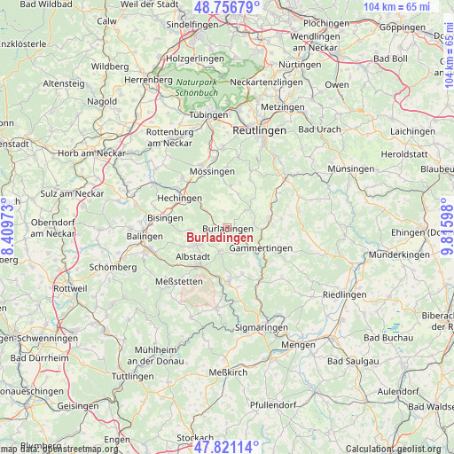
Burladingen GPS coordinates[2]
48° 17' 27.996" North, 9° 6' 46.296" East
| Map corner | latitude | longitude |
|---|---|---|
| Upper-left | 48.75679°, | 8.40973° |
| Center: | 48.29111°, | 9.11286° |
| Lower-right: | 47.82114°, | 9.81598° |
| Map W x H: | 104×104 km | = 64.6×64.6mi |
| max Lat: | 55.01917° ⇑91.3% North |
| Burladingen: | 48.29111° |
| min Lat: | ⇓8.7% South 47.40724° |
| min Long | Burladingen | max Long |
| 5.92978° | 9.11286° | 14.98853° |
| W 36.2%⇐ | ⇒63.8% E |
Elevation
Elevation of Burladingen is 738 m = 2421 ft, and this is 488.9 m = 1604 ft above average elevation for this country.
| Max E: |
1256 m = 4121 ft | 1.5% |
| Burladingen | 738 m 2421 ft | |
| Avg. | 249.1 m = 817 ft | |
Min E: |
-5 m = -16 ft | 98.5% |
See also: Germany elevation on elevation.city.
Geographical zone
Burladingen is located in North temperate zone (between Tropic of Cancer and the Arctic Circle). Distance of this North polar circle is 2031.7 km =1262.4 mi to North.| Distance of | km | miles | from Burladingen |
|---|---|---|---|
| North Pole | 4637.6 | 2881.7 | to North |
| Arctic Circle | 2031.7 | 1262.4 | to North |
| Tropic Cancer | 2763.5 | 1717.2 | to South |
| Equator | 5369.5 | 3336.5 | to South |


Nearby cities:
15 places around Burladingen: (largest is in red/bold)
• Albstadt
10.5 km =6.5 mi,  217°
217°
• Bisingen
14.6 km =9.1 mi,  278°
278°
• Bitz
5.5 km =3.4 mi,  196°
196°
• Bodelshausen
14.8 km =9.2 mi,  317°
317°
• Gammertingen
9.2 km =5.7 mi,  117°
117°
• Hechingen
12.9 km =8 mi,  301°
301°
• Hettingen
12.1 km =7.5 mi,  133°
133°
• Jungingen
6.7 km =4.2 mi,  307°
307°
• Mössingen
13.5 km =8.4 mi,  341°
341°
• Neufra
7.1 km =4.4 mi, 132°
• Ofterdingen
15.1 km =9.4 mi, 337°
• Straßberg
12.7 km =7.9 mi,  187°
187°
• Trochtelfingen
10 km =6.2 mi,  78°
78°
• Veringenstadt
13.8 km =8.6 mi,  148°
148°
• Winterlingen
12 km =7.5 mi,  178°
178°
Sources, notices
• [Note1] Compared only with cities in Germany existing in our database
• [Src1] Map data: © OpenStreetMap contributors (CC-BY-SA)
• [Src2] Other city data from geonames.org with taken over terms of usage.
• [Src3] Geographical zone / Annual Mean Temperature by Robert A. Rohde @ Wikipedia
