Rangendingen geodata
Rangendingen (Baden-Württemberg) is a seat of a fourth-order administrative division; located in Germany in Europe/Berlin (GMT+2) time zone. With population of 5,187 people, there are 2747 cities with bigger population in this country. Compared to other cities in Germany, 90.5% of cities are located further ↑North; 66.8% of cities are located further →East and 77.9% of cities have lower elevation than Rangendingen. Note1
Administrative division(s):
- Level 1: Baden-Württemberg
- Level 2: Tübingen Region
- Level 3: Zollernalbkreis
- Level 4: Rangendingen


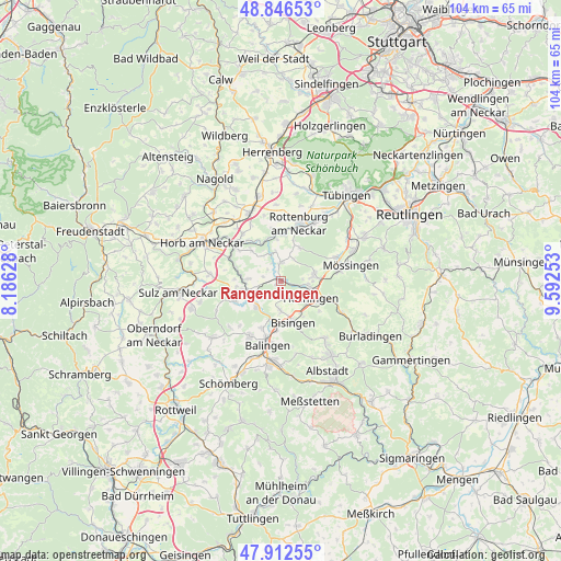
Rangendingen GPS coordinates[2]
48° 22' 54.048" North, 8° 53' 21.84" East
| Map corner | latitude | longitude |
|---|---|---|
| Upper-left | 48.84653°, | 8.18628° |
| Center: | 48.38168°, | 8.8894° |
| Lower-right: | 47.91255°, | 9.59253° |
| Map W x H: | 103.8×103.8 km | = 64.5×64.5mi |
| max Lat: | 55.01917° ⇑90.5% North |
| Rangendingen: | 48.38168° |
| min Lat: | ⇓9.5% South 47.40724° |
| min Long | Rangendingen | max Long |
| 5.92978° | 8.8894° | 14.98853° |
| W 33.2%⇐ | ⇒66.8% E |
Elevation
Elevation of Rangendingen is 418 m = 1371 ft, and this is 168.9 m = 554 ft above average elevation for this country.
| Max E: |
1256 m = 4121 ft | 22.1% |
| Rangendingen | 418 m 1371 ft | |
| Avg. | 249.1 m = 817 ft | |
Min E: |
-5 m = -16 ft | 77.9% |
See also: Germany elevation on elevation.city.
Geographical zone
Rangendingen is located in North temperate zone (between Tropic of Cancer and the Arctic Circle). Distance of this North polar circle is 2021.6 km =1256.2 mi to North.| Distance of | km | miles | from Rangendingen |
|---|---|---|---|
| North Pole | 4627.5 | 2875.4 | to North |
| Arctic Circle | 2021.6 | 1256.2 | to North |
| Tropic Cancer | 2773.6 | 1723.4 | to South |
| Equator | 5379.5 | 3342.7 | to South |


Nearby cities:
15 places around Rangendingen: (largest is in red/bold)
• Balingen
12.1 km =7.5 mi,  192°
192°
• Bisingen
8.2 km =5.1 mi,  165°
165°
• Bodelshausen
6.5 km =4 mi,  82°
82°
• Empfingen
13.3 km =8.3 mi,  275°
275°
• Geislingen
11.9 km =7.4 mi,  208°
208°
• Grosselfingen
5.5 km =3.4 mi,  181°
181°
• Haigerloch
6.6 km =4.1 mi,  254°
254°
• Hechingen
6.4 km =4 mi,  121°
121°
• Hirrlingen
3.4 km =2.1 mi,  357°
357°
• Jungingen
12.7 km =7.9 mi, 118°
• Mössingen
12.5 km =7.8 mi, 77°
• Mühlheim am Bach
14.2 km =8.8 mi,  268°
268°
• Nehren
14.4 km =8.9 mi,  67°
67°
• Ofterdingen
11.3 km =7 mi, 69°
• Rottenburg
11.1 km =6.9 mi,  17°
17°
Sources, notices
• [Note1] Compared only with cities in Germany existing in our database
• [Src1] Map data: © OpenStreetMap contributors (CC-BY-SA)
• [Src2] Other city data from geonames.org with taken over terms of usage.
• [Src3] Geographical zone / Annual Mean Temperature by Robert A. Rohde @ Wikipedia
