Neufra geodata
Neufra (Baden-Württemberg) is a seat of a fourth-order administrative division; located in Germany in Europe/Berlin (GMT+2) time zone. In our database, there are 11009 cities with bigger population. Compared to other cities in Germany, 92% of cities are located further ↑North; 62.7% of cities are located further →East and 97.5% of cities have lower elevation than Neufra. Note1
Administrative division(s):
- Level 1: Baden-Württemberg
- Level 2: Tübingen Region
- Level 3: Landkreis Sigmaringen
- Level 4: Neufra


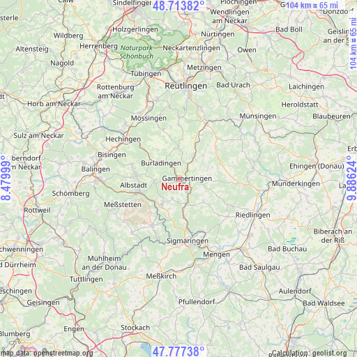
Neufra GPS coordinates[2]
48° 14' 51.864" North, 9° 10' 59.196" East
| Map corner | latitude | longitude |
|---|---|---|
| Upper-left | 48.71382°, | 8.47999° |
| Center: | 48.24774°, | 9.18311° |
| Lower-right: | 47.77738°, | 9.88624° |
| Map W x H: | 104.1×104.1 km | = 64.7×64.7mi |
| max Lat: | 55.01917° ⇑92% North |
| Neufra: | 48.24774° |
| min Lat: | ⇓8% South 47.40724° |
| min Long | Neufra | max Long |
| 5.92978° | 9.18311° | 14.98853° |
| W 37.3%⇐ | ⇒62.7% E |
Elevation
Elevation of Neufra is 681 m = 2234 ft, and this is 431.9 m = 1417 ft above average elevation for this country.
| Max E: |
1256 m = 4121 ft | 2.5% |
| Neufra | 681 m 2234 ft | |
| Avg. | 249.1 m = 817 ft | |
Min E: |
-5 m = -16 ft | 97.5% |
See also: Germany elevation on elevation.city.
Geographical zone
Neufra is located in North temperate zone (between Tropic of Cancer and the Arctic Circle). Distance of this North polar circle is 2036.5 km =1265.4 mi to North.| Distance of | km | miles | from Neufra |
|---|---|---|---|
| North Pole | 4642.4 | 2884.7 | to North |
| Arctic Circle | 2036.5 | 1265.4 | to North |
| Tropic Cancer | 2758.7 | 1714.2 | to South |
| Equator | 5364.6 | 3333.4 | to South |


Nearby cities:
15 places around Neufra: (largest is in red/bold)
• Albstadt
12.1 km =7.5 mi,  253°
253°
• Bingen
16.6 km =10.3 mi,  156°
156°
• Bitz
6.8 km =4.2 mi,  266°
266°
• Burladingen
7.1 km =4.4 mi,  312°
312°
• Gammertingen
3 km =1.9 mi,  80°
80°
• Hettingen
5 km =3.1 mi,  134°
134°
• Jungingen
13.8 km =8.6 mi, 310°
• Meßstetten
17.6 km =10.9 mi, 245°
• Pfronstetten
13.5 km =8.4 mi, 76°
• Sigmaringen
18.1 km =11.2 mi,  168°
168°
• Stetten am Kalten Markt
15.8 km =9.8 mi,  209°
209°
• Straßberg
10.3 km =6.4 mi,  221°
221°
• Trochtelfingen
8.2 km =5.1 mi,  34°
34°
• Veringenstadt
7.3 km =4.5 mi, 163°
• Winterlingen
8.7 km =5.4 mi, 214°
Sources, notices
• [Note1] Compared only with cities in Germany existing in our database
• [Src1] Map data: © OpenStreetMap contributors (CC-BY-SA)
• [Src2] Other city data from geonames.org with taken over terms of usage.
• [Src3] Geographical zone / Annual Mean Temperature by Robert A. Rohde @ Wikipedia
