Jagstzell geodata
Jagstzell (Baden-Württemberg) is a seat of a fourth-order administrative division; located in Germany in Europe/Berlin (GMT+2) time zone. With population of 2,470 people, there are 4474 cities with bigger population in this country. Compared to other cities in Germany, 82.7% of cities are located further ↑North; 51.6% of cities are located further ←West and 79% of cities have lower elevation than Jagstzell. Note1
Administrative division(s):
- Level 1: Baden-Württemberg
- Level 2: Regierungsbezirk Stuttgart
- Level 3: Ostalbkreis
- Level 4: Jagstzell


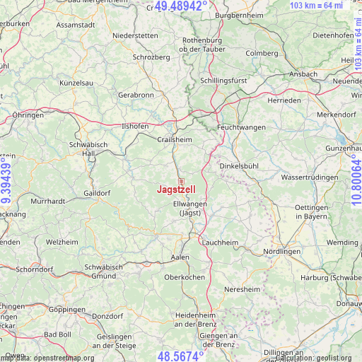
Jagstzell GPS coordinates[2]
49° 1' 49.98" North, 10° 5' 51.036" East
| Map corner | latitude | longitude |
|---|---|---|
| Upper-left | 49.48942°, | 9.39439° |
| Center: | 49.03055°, | 10.09751° |
| Lower-right: | 48.5674°, | 10.80064° |
| Map W x H: | 102.5×102.5 km | = 63.7×63.7mi |
| max Lat: | 55.01917° ⇑82.7% North |
| Jagstzell: | 49.03055° |
| min Lat: | ⇓17.3% South 47.40724° |
| min Long | Jagstzell | max Long |
| 5.92978° | 10.09751° | 14.98853° |
| W 51.6%⇐ | ⇒48.4% E |
Elevation
Elevation of Jagstzell is 427 m = 1401 ft, and this is 177.9 m = 584 ft above average elevation for this country.
| Max E: |
1256 m = 4121 ft | 21% |
| Jagstzell | 427 m 1401 ft | |
| Avg. | 249.1 m = 817 ft | |
Min E: |
-5 m = -16 ft | 79% |
See also: Germany elevation on elevation.city.
Geographical zone
Jagstzell is located in North temperate zone (between Tropic of Cancer and the Arctic Circle). Distance of this North polar circle is 1949.5 km =1211.4 mi to North.| Distance of | km | miles | from Jagstzell |
|---|---|---|---|
| North Pole | 4555.4 | 2830.6 | to North |
| Arctic Circle | 1949.5 | 1211.4 | to North |
| Tropic Cancer | 2845.8 | 1768.3 | to South |
| Equator | 5451.7 | 3387.5 | to South |


Nearby cities:
15 places around Jagstzell: (largest is in red/bold)
• Adelmannsfelden
10.8 km =6.7 mi,  218°
218°
• Bühlertann
13.8 km =8.6 mi,  275°
275°
• Bühlerzell
13.3 km =8.3 mi,  256°
256°
• Crailsheim
11.7 km =7.3 mi,  350°
350°
• Ellenberg
8.8 km =5.5 mi,  100°
100°
• Ellwangen
8.1 km =5 mi,  161°
161°
• Gerabronn
14.6 km =9.1 mi,  242°
242°
• Hüttlingen
15.3 km =9.5 mi,  179°
179°
• Neuler
11.6 km =7.2 mi,  190°
190°
• Obersontheim
14.7 km =9.1 mi, 281°
• Rosenberg
5.1 km =3.2 mi, 255°
• Satteldorf
15.5 km =9.6 mi,  355°
355°
• Stimpfach
3.4 km =2.1 mi, 354°
• Stödtlen
15.2 km =9.4 mi, 102°
• Wört
12.7 km =7.9 mi,  90°
90°
Sources, notices
• [Note1] Compared only with cities in Germany existing in our database
• [Src1] Map data: © OpenStreetMap contributors (CC-BY-SA)
• [Src2] Other city data from geonames.org with taken over terms of usage.
• [Src3] Geographical zone / Annual Mean Temperature by Robert A. Rohde @ Wikipedia
