Ellwangen geodata
Ellwangen (Baden-Württemberg) is a populated place; located in Germany in Europe/Berlin (GMT+2) time zone. With population of 25,276 people, there are 577 cities with bigger population in this country. Compared to other cities in Germany, 83.4% of cities are located further ↑North; 52.1% of cities are located further ←West and 81.4% of cities have lower elevation than Ellwangen. Note1
Administrative division(s):
- Level 1: Baden-Württemberg
- Level 2: Regierungsbezirk Stuttgart
- Level 3: Ostalbkreis
- Level 4: Ellwangen (Jagst)


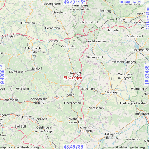
Ellwangen GPS coordinates[2]
48° 57' 41.904" North, 10° 7' 54.228" East
| Map corner | latitude | longitude |
|---|---|---|
| Upper-left | 49.42115°, | 9.42861° |
| Center: | 48.96164°, | 10.13173° |
| Lower-right: | 48.49786°, | 10.83486° |
| Map W x H: | 102.7×102.7 km | = 63.8×63.8mi |
| max Lat: | 55.01917° ⇑83.4% North |
| Ellwangen: | 48.96164° |
| min Lat: | ⇓16.6% South 47.40724° |
| min Long | Ellwangen | max Long |
| 5.92978° | 10.13173° | 14.98853° |
| W 52.1%⇐ | ⇒47.9% E |
Elevation
Elevation of Ellwangen is 443 m = 1453 ft, and this is 193.9 m = 636 ft above average elevation for this country.
| Max E: |
1256 m = 4121 ft | 18.6% |
| Ellwangen | 443 m 1453 ft | |
| Avg. | 249.1 m = 817 ft | |
Min E: |
-5 m = -16 ft | 81.4% |
See also: Germany elevation on elevation.city.
Geographical zone
Ellwangen is located in North temperate zone (between Tropic of Cancer and the Arctic Circle). Distance of this North polar circle is 1957.2 km =1216.1 mi to North.| Distance of | km | miles | from Ellwangen |
|---|---|---|---|
| North Pole | 4563 | 2835.3 | to North |
| Arctic Circle | 1957.2 | 1216.1 | to North |
| Tropic Cancer | 2838.1 | 1763.5 | to South |
| Equator | 5444 | 3382.7 | to South |


Nearby cities:
15 places around Ellwangen: (largest is in red/bold)
• Aalen
14.1 km =8.8 mi,  191°
191°
• Abtsgmünd
12 km =7.5 mi,  232°
232°
• Adelmannsfelden
9.3 km =5.8 mi,  265°
265°
• Bühlerzell
16.1 km =10 mi,  286°
286°
• Ellenberg
8.7 km =5.4 mi,  45°
45°
• Gerabronn
15.5 km =9.6 mi, 273°
• Hüttlingen
8 km =5 mi,  196°
196°
• Jagstzell
8.1 km =5 mi,  341°
341°
• Lauchheim
12.9 km =8 mi,  141°
141°
• Neuler
5.9 km =3.7 mi, 230°
• Rosenberg
9.8 km =6.1 mi,  310°
310°
• Stimpfach
11.4 km =7.1 mi,  345°
345°
• Stödtlen
13 km =8.1 mi,  70°
70°
• Westhausen
9.5 km =5.9 mi,  156°
156°
• Wört
12.8 km =8 mi, 53°
Sources, notices
• [Note1] Compared only with cities in Germany existing in our database
• [Src1] Map data: © OpenStreetMap contributors (CC-BY-SA)
• [Src2] Other city data from geonames.org with taken over terms of usage.
• [Src3] Geographical zone / Annual Mean Temperature by Robert A. Rohde @ Wikipedia
