Hüttlingen geodata
Hüttlingen (Baden-Württemberg) is a seat of a fourth-order administrative division; located in Germany in Europe/Berlin (GMT+2) time zone. With population of 5,678 people, there are 2574 cities with bigger population in this country. Compared to other cities in Germany, 84.2% of cities are located further ↑North; 51.7% of cities are located further ←West and 76.2% of cities have lower elevation than Hüttlingen. Note1
Administrative division(s):
- Level 1: Baden-Württemberg
- Level 2: Regierungsbezirk Stuttgart
- Level 3: Ostalbkreis
- Level 4: Hüttlingen


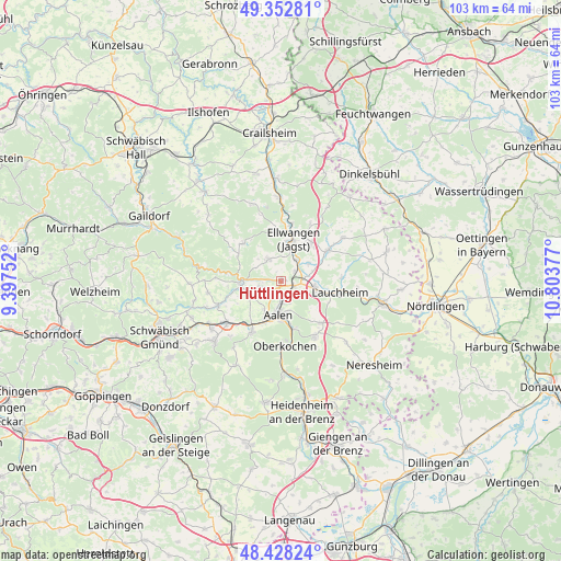
Hüttlingen GPS coordinates[2]
48° 53' 33.576" North, 10° 6' 2.304" East
| Map corner | latitude | longitude |
|---|---|---|
| Upper-left | 49.35281°, | 9.39752° |
| Center: | 48.89266°, | 10.10064° |
| Lower-right: | 48.42824°, | 10.80377° |
| Map W x H: | 102.8×102.8 km | = 63.9×63.9mi |
| max Lat: | 55.01917° ⇑84.2% North |
| Hüttlingen: | 48.89266° |
| min Lat: | ⇓15.8% South 47.40724° |
| min Long | Hüttlingen | max Long |
| 5.92978° | 10.10064° | 14.98853° |
| W 51.7%⇐ | ⇒48.3% E |
Elevation
Elevation of Hüttlingen is 407 m = 1335 ft, and this is 157.9 m = 518 ft above average elevation for this country.
| Max E: |
1256 m = 4121 ft | 23.8% |
| Hüttlingen | 407 m 1335 ft | |
| Avg. | 249.1 m = 817 ft | |
Min E: |
-5 m = -16 ft | 76.2% |
See also: Germany elevation on elevation.city.
Geographical zone
Hüttlingen is located in North temperate zone (between Tropic of Cancer and the Arctic Circle). Distance of this North polar circle is 1964.8 km =1220.9 mi to North.| Distance of | km | miles | from Hüttlingen |
|---|---|---|---|
| North Pole | 4570.7 | 2840.1 | to North |
| Arctic Circle | 1964.8 | 1220.9 | to North |
| Tropic Cancer | 2830.4 | 1758.7 | to South |
| Equator | 5436.4 | 3378 | to South |


Nearby cities:
15 places around Hüttlingen: (largest is in red/bold)
• Aalen
6.1 km =3.8 mi,  185°
185°
• Abtsgmünd
7.2 km =4.5 mi,  272°
272°
• Adelmannsfelden
9.8 km =6.1 mi,  314°
314°
• Ellwangen
8 km =5 mi,  16°
16°
• Essingen
10.8 km =6.7 mi,  209°
209°
• Heuchlingen
12.3 km =7.6 mi,  248°
248°
• Jagstzell
15.3 km =9.5 mi,  359°
359°
• Lauchheim
10.6 km =6.6 mi,  102°
102°
• Mögglingen
12.7 km =7.9 mi,  232°
232°
• Neuler
4.6 km =2.9 mi,  329°
329°
• Obergröningen
14 km =8.7 mi, 270°
• Oberkochen
12.1 km =7.5 mi,  178°
178°
• Rosenberg
15 km =9.3 mi,  339°
339°
• Schechingen
13.6 km =8.5 mi,  260°
260°
• Westhausen
6.1 km =3.8 mi, 99°
Sources, notices
• [Note1] Compared only with cities in Germany existing in our database
• [Src1] Map data: © OpenStreetMap contributors (CC-BY-SA)
• [Src2] Other city data from geonames.org with taken over terms of usage.
• [Src3] Geographical zone / Annual Mean Temperature by Robert A. Rohde @ Wikipedia
