Ellenberg geodata
Ellenberg (Baden-Württemberg) is a seat of a fourth-order administrative division; located in Germany in Europe/Berlin (GMT+2) time zone. With population of 1,693 people, there are 5525 cities with bigger population in this country. Compared to other cities in Germany, 82.9% of cities are located further ↑North; 53.6% of cities are located further ←West and 94.1% of cities have lower elevation than Ellenberg. Note1
Administrative division(s):
- Level 1: Baden-Württemberg
- Level 2: Regierungsbezirk Stuttgart
- Level 3: Ostalbkreis
- Level 4: Ellenberg


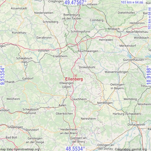
Ellenberg GPS coordinates[2]
49° 1' 0.012" North, 10° 13' 0.012" East
| Map corner | latitude | longitude |
|---|---|---|
| Upper-left | 49.47567°, | 9.51354° |
| Center: | 49.01667°, | 10.21667° |
| Lower-right: | 48.5534°, | 10.9198° |
| Map W x H: | 102.5×102.5 km | = 63.7×63.7mi |
| max Lat: | 55.01917° ⇑82.9% North |
| Ellenberg: | 49.01667° |
| min Lat: | ⇓17.1% South 47.40724° |
| min Long | Ellenberg | max Long |
| 5.92978° | 10.21667° | 14.98853° |
| W 53.6%⇐ | ⇒46.4% E |
Elevation
Elevation of Ellenberg is 576 m = 1890 ft, and this is 326.9 m = 1073 ft above average elevation for this country.
| Max E: |
1256 m = 4121 ft | 5.9% |
| Ellenberg | 576 m 1890 ft | |
| Avg. | 249.1 m = 817 ft | |
Min E: |
-5 m = -16 ft | 94.1% |
See also: Germany elevation on elevation.city.
Geographical zone
Ellenberg is located in North temperate zone (between Tropic of Cancer and the Arctic Circle). Distance of this North polar circle is 1951 km =1212.3 mi to North.| Distance of | km | miles | from Ellenberg |
|---|---|---|---|
| North Pole | 4556.9 | 2831.5 | to North |
| Arctic Circle | 1951 | 1212.3 | to North |
| Tropic Cancer | 2844.2 | 1767.3 | to South |
| Equator | 5450.1 | 3386.5 | to South |


Nearby cities:
15 places around Ellenberg: (largest is in red/bold)
• Dinkelsbühl
9.5 km =5.9 mi,  52°
52°
• Dürrwangen
15.9 km =9.9 mi, 50°
• Ellwangen
8.7 km =5.4 mi,  225°
225°
• Jagstzell
8.8 km =5.5 mi,  280°
280°
• Mönchsroth
10.3 km =6.4 mi,  88°
88°
• Neuler
14.6 km =9.1 mi, 227°
• Rosenberg
13.6 km =8.5 mi,  271°
271°
• Schopfloch
13.2 km =8.2 mi,  30°
30°
• Stimpfach
10.3 km =6.4 mi,  298°
298°
• Stödtlen
6.4 km =4 mi,  106°
106°
• Tannhausen
11.4 km =7.1 mi, 111°
• Unterschneidheim
14.3 km =8.9 mi,  130°
130°
• Westhausen
15 km =9.3 mi,  189°
189°
• Wilburgstetten
13 km =8.1 mi, 86°
• Wört
4.3 km =2.7 mi,  69°
69°
Sources, notices
• [Note1] Compared only with cities in Germany existing in our database
• [Src1] Map data: © OpenStreetMap contributors (CC-BY-SA)
• [Src2] Other city data from geonames.org with taken over terms of usage.
• [Src3] Geographical zone / Annual Mean Temperature by Robert A. Rohde @ Wikipedia
