Gifhorn geodata
Gifhorn (Lower Saxony) is a seat of a third-order administrative division; located in Germany in Europe/Berlin (GMT+2) time zone. With population of 43,000 people, there are 286 cities with bigger population in this country. Compared to other cities in Germany, 77.2% of cities are located further ↓South; 59.8% of cities are located further ←West and 76.4% of cities have higher elevation than Gifhorn. Note1


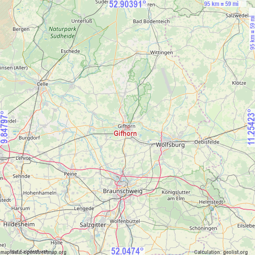
Gifhorn GPS coordinates[2]
52° 28' 39.864" North, 10° 33' 3.96" East
| Map corner | latitude | longitude |
|---|---|---|
| Upper-left | 52.90391°, | 9.84797° |
| Center: | 52.47774°, | 10.5511° |
| Lower-right: | 52.0474°, | 11.25423° |
| Map W x H: | 95.2×95.2 km | = 59.2×59.2mi |
| max Lat: | 55.01917° ⇑22.8% North |
| Gifhorn: | 52.47774° |
| min Lat: | ⇓77.2% South 47.40724° |
| min Long | Gifhorn | max Long |
| 5.92978° | 10.5511° | 14.98853° |
| W 59.8%⇐ | ⇒40.2% E |
Elevation
Elevation of Gifhorn is 58 m = 190 ft, and this is 191.1 m = 627 ft below average elevation for this country.
| Max E: |
1256 m = 4121 ft | 76.4% |
| Avg. | 249.1 m = 817 ft | |
| Gifhorn | 58 m = 190 ft | |
Min E: |
-5 m = -16 ft | 23.6% |
See also: Gifhorn elevation on elevation.city.
Geographical zone
Gifhorn is located in North temperate zone (between Tropic of Cancer and the Arctic Circle). Distance of this North polar circle is 1566.2 km =973.2 mi to North.| Distance of | km | miles | from Gifhorn |
|---|---|---|---|
| North Pole | 4172.1 | 2592.4 | to North |
| Arctic Circle | 1566.2 | 973.2 | to North |
| Tropic Cancer | 3229.1 | 2006.5 | to South |
| Equator | 5835 | 3625.7 | to South |


Nearby cities:
15 places around Gifhorn: (largest is in red/bold)
• Allerbüttel
8.7 km =5.4 mi,  136°
136°
• Bokensdorf
11.5 km =7.1 mi,  77°
77°
• Calberlah
8 km =5 mi, 142°
• Hillerse
12.3 km =7.6 mi,  236°
236°
• Isenbüttel
5.4 km =3.4 mi,  156°
156°
• Leiferde
9 km =5.6 mi, 241°
• Meine
10.4 km =6.5 mi,  184°
184°
• Osloß
8.8 km =5.5 mi,  96°
96°
• Rethen
12.2 km =7.6 mi,  203°
203°
• Ribbesbüttel
5.6 km =3.5 mi,  210°
210°
• Rötgesbüttel
6.9 km =4.3 mi,  190°
190°
• Sassenburg
7.1 km =4.4 mi,  52°
52°
• Wagenhoff
8.5 km =5.3 mi,  347°
347°
• Wasbüttel
7.7 km =4.8 mi, 158°
• Weyhausen
11.4 km =7.1 mi, 98°
Sources, notices
• [Note1] Compared only with cities in Germany existing in our database
• [Src1] Map data: © OpenStreetMap contributors (CC-BY-SA)
• [Src2] Other city data from geonames.org with taken over terms of usage.
• [Src3] Geographical zone / Annual Mean Temperature by Robert A. Rohde @ Wikipedia
