Grünberg geodata
Grünberg (Hesse) is a populated place; located in Germany in Europe/Berlin (GMT+2) time zone. With population of 14,233 people, there are 1115 cities with bigger population in this country. Compared to other cities in Germany, 50.7% of cities are located further ↑North; 66% of cities are located further →East and 56.5% of cities have lower elevation than Grünberg. Note1
Administrative division(s):
- Level 1: Hesse
- Level 2: Regierungsbezirk Gießen
- Level 3: Landkreis Gießen
- Level 4: Grünberg


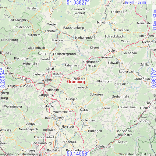
Grünberg GPS coordinates[2]
50° 35' 38.508" North, 8° 57' 31.176" East
| Map corner | latitude | longitude |
|---|---|---|
| Upper-left | 51.03827°, | 8.25554° |
| Center: | 50.59403°, | 8.95866° |
| Lower-right: | 50.14556°, | 9.66179° |
| Map W x H: | 99.3×99.3 km | = 61.7×61.7mi |
| max Lat: | 55.01917° ⇑50.7% North |
| Grünberg: | 50.59403° |
| min Lat: | ⇓49.3% South 47.40724° |
| min Long | Grünberg | max Long |
| 5.92978° | 8.95866° | 14.98853° |
| W 34%⇐ | ⇒66% E |
Elevation
Elevation of Grünberg is 269 m = 883 ft, and this is 19.9 m = 65 ft above average elevation for this country.
| Max E: |
1256 m = 4121 ft | 43.5% |
| Grünberg | 269 m 883 ft | |
| Avg. | 249.1 m = 817 ft | |
Min E: |
-5 m = -16 ft | 56.5% |
See also: Germany elevation on elevation.city.
Geographical zone
Grünberg is located in North temperate zone (between Tropic of Cancer and the Arctic Circle). Distance of this North polar circle is 1775.6 km =1103.3 mi to North.| Distance of | km | miles | from Grünberg |
|---|---|---|---|
| North Pole | 4381.5 | 2722.5 | to North |
| Arctic Circle | 1775.6 | 1103.3 | to North |
| Tropic Cancer | 3019.6 | 1876.3 | to South |
| Equator | 5625.5 | 3495.5 | to South |


Nearby cities:
15 places around Grünberg: (largest is in red/bold)
• Alten Buseck
14.8 km =9.2 mi,  282°
282°
• Beuern
10.4 km =6.5 mi,  290°
290°
• Ebsdorfergrund
16.3 km =10.1 mi,  333°
333°
• Großen Buseck
12.3 km =7.6 mi, 275°
• Homberg
15.5 km =9.6 mi,  9°
9°
• Hungen
14.2 km =8.8 mi,  199°
199°
• Höingen
14.2 km =8.8 mi,  348°
348°
• Laubach
6.2 km =3.9 mi,  158°
158°
• Lich
13 km =8.1 mi,  231°
231°
• Rabenau
11.4 km =7.1 mi,  324°
324°
• Reiskirchen
8.9 km =5.5 mi,  274°
274°
• Schotten
15.5 km =9.6 mi,  130°
130°
• Steinheim
16.9 km =10.5 mi,  188°
188°
• Trohe
14.6 km =9.1 mi, 276°
• Ulrichstein
16.7 km =10.4 mi,  97°
97°
Sources, notices
• [Note1] Compared only with cities in Germany existing in our database
• [Src1] Map data: © OpenStreetMap contributors (CC-BY-SA)
• [Src2] Other city data from geonames.org with taken over terms of usage.
• [Src3] Geographical zone / Annual Mean Temperature by Robert A. Rohde @ Wikipedia
