Oberschneiding geodata
Oberschneiding (Bavaria) is a seat of a fourth-order administrative division; located in Germany in Europe/Berlin (GMT+2) time zone. With population of 2,745 people, there are 4202 cities with bigger population in this country. Compared to other cities in Germany, 85.4% of cities are located further ↑North; 89.3% of cities are located further ←West and 70.1% of cities have lower elevation than Oberschneiding. Note1
Administrative division(s):
- Level 1: Bavaria
- Level 2: Lower Bavaria
- Level 3: Landkreis Straubing-Bogen
- Level 4: Oberschneiding


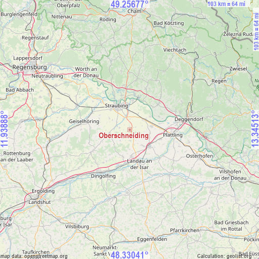
Oberschneiding GPS coordinates[2]
48° 47' 44.628" North, 12° 38' 31.2" East
| Map corner | latitude | longitude |
|---|---|---|
| Upper-left | 49.25677°, | 11.93888° |
| Center: | 48.79573°, | 12.642° |
| Lower-right: | 48.33041°, | 13.34513° |
| Map W x H: | 103×103 km | = 64×64mi |
| max Lat: | 55.01917° ⇑85.4% North |
| Oberschneiding: | 48.79573° |
| min Lat: | ⇓14.6% South 47.40724° |
| min Long | Oberschneiding | max Long |
| 5.92978° | 12.642° | 14.98853° |
| W 89.3%⇐ | ⇒10.7% E |
Elevation
Elevation of Oberschneiding is 359 m = 1178 ft, and this is 109.9 m = 361 ft above average elevation for this country.
| Max E: |
1256 m = 4121 ft | 29.9% |
| Oberschneiding | 359 m 1178 ft | |
| Avg. | 249.1 m = 817 ft | |
Min E: |
-5 m = -16 ft | 70.1% |
See also: Germany elevation on elevation.city.
Geographical zone
Oberschneiding is located in North temperate zone (between Tropic of Cancer and the Arctic Circle). Distance of this North polar circle is 1975.6 km =1227.6 mi to North.| Distance of | km | miles | from Oberschneiding |
|---|---|---|---|
| North Pole | 4581.5 | 2846.8 | to North |
| Arctic Circle | 1975.6 | 1227.6 | to North |
| Tropic Cancer | 2819.7 | 1752.1 | to South |
| Equator | 5425.6 | 3371.3 | to South |


Nearby cities:
15 places around Oberschneiding: (largest is in red/bold)
• Alterhofen
5.9 km =3.7 mi,  344°
344°
• Bogen
13.3 km =8.3 mi,  15°
15°
• Feldkirchen
9.6 km =6 mi,  299°
299°
• Hunderdorf
10.9 km =6.8 mi,  12°
12°
• Irlbach
9.5 km =5.9 mi,  57°
57°
• Leiblfing
9.4 km =5.8 mi,  256°
256°
• Mariaposching
12.3 km =7.6 mi,  70°
70°
• Otzing
12.8 km =8 mi,  107°
107°
• Parkstetten
13.8 km =8.6 mi,  347°
347°
• Pilsting
10.5 km =6.5 mi,  176°
176°
• Salching
5.5 km =3.4 mi,  287°
287°
• Stephansposching
11.8 km =7.3 mi,  78°
78°
• Straubing
10.7 km =6.6 mi,  332°
332°
• Straßkirchen
7 km =4.3 mi, 56°
• Wallersdorf
10.1 km =6.3 mi,  129°
129°
Sources, notices
• [Note1] Compared only with cities in Germany existing in our database
• [Src1] Map data: © OpenStreetMap contributors (CC-BY-SA)
• [Src2] Other city data from geonames.org with taken over terms of usage.
• [Src3] Geographical zone / Annual Mean Temperature by Robert A. Rohde @ Wikipedia
