Schieder-Schwalenberg geodata
Schieder-Schwalenberg (North Rhine-Westphalia) is a populated place; located in Germany in Europe/Berlin (GMT+2) time zone. With population of 9,443 people, there are 1712 cities with bigger population in this country. Compared to other cities in Germany, 70.8% of cities are located further ↓South; 62.5% of cities are located further →East and 51% of cities have higher elevation than Schieder-Schwalenberg. Note1
Administrative division(s):
- Level 1: North Rhine-Westphalia
- Level 2: Regierungsbezirk Detmold
- Level 3: Kreis Lippe
- Level 4: Schieder-Schwalenberg


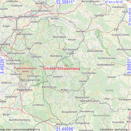
Schieder-Schwalenberg GPS coordinates[2]
51° 52' 37.668" North, 9° 11' 43.368" East
| Map corner | latitude | longitude |
|---|---|---|
| Upper-left | 52.30911°, | 8.49226° |
| Center: | 51.87713°, | 9.19538° |
| Lower-right: | 51.44096°, | 9.89851° |
| Map W x H: | 96.5×96.5 km | = 60×60mi |
| max Lat: | 55.01917° ⇑29.2% North |
| Schieder-Schwalenberg: | 51.87713° |
| min Lat: | ⇓70.8% South 47.40724° |
| min Long | Schieder-Schwal | max Long |
| 5.92978° | 9.19538° | 14.98853° |
| W 37.5%⇐ | ⇒62.5% E |
Elevation
Elevation of Schieder-Schwalenberg is 218 m = 715 ft, and this is 31.1 m = 102 ft below average elevation for this country.
| Max E: |
1256 m = 4121 ft | 51% |
| Avg. | 249.1 m = 817 ft | |
| Schieder-Schwalenberg | 218 m = 715 ft | |
Min E: |
-5 m = -16 ft | 49% |
See also: Germany elevation on elevation.city.
Geographical zone
Schieder-Schwalenberg is located in North temperate zone (between Tropic of Cancer and the Arctic Circle). Distance of this North polar circle is 1633 km =1014.7 mi to North.| Distance of | km | miles | from Schieder-Schwalenberg |
|---|---|---|---|
| North Pole | 4238.9 | 2633.9 | to North |
| Arctic Circle | 1633 | 1014.7 | to North |
| Tropic Cancer | 3162.3 | 1965 | to South |
| Equator | 5768.2 | 3584.2 | to South |


Nearby cities:
15 places around Schieder-Schwalenberg: (largest is in red/bold)
• Bad Meinberg
14.7 km =9.1 mi,  278°
278°
• Bad Pyrmont
12.7 km =7.9 mi,  17°
17°
• Barntrup
13.7 km =8.5 mi,  336°
336°
• Blomberg
10.3 km =6.4 mi,  315°
315°
• Brevörde
15.8 km =9.8 mi,  73°
73°
• Heinsen
16.3 km =10.1 mi,  87°
87°
• Horn
17.2 km =10.7 mi,  267°
267°
• Horn-Bad Meinberg
16 km =9.9 mi, 273°
• Höxter
17.1 km =10.6 mi,  131°
131°
• Lügde
9.7 km =6 mi, 21°
• Nieheim
9.8 km =6.1 mi,  215°
215°
• Ottenstein
16.5 km =10.3 mi,  61°
61°
• Polle
14.5 km =9 mi,  80°
80°
• Steinheim
7.2 km =4.5 mi,  264°
264°
• Vahlbruch
11.1 km =6.9 mi, 64°
Sources, notices
• [Note1] Compared only with cities in Germany existing in our database
• [Src1] Map data: © OpenStreetMap contributors (CC-BY-SA)
• [Src2] Other city data from geonames.org with taken over terms of usage.
• [Src3] Geographical zone / Annual Mean Temperature by Robert A. Rohde @ Wikipedia
