Brakel geodata
Brakel (North Rhine-Westphalia) is a populated place; located in Germany in Europe/Berlin (GMT+2) time zone. With population of 17,808 people, there are 892 cities with bigger population in this country. Compared to other cities in Germany, 69% of cities are located further ↓South; 62.6% of cities are located further →East and 62.3% of cities have higher elevation than Brakel. Note1
Administrative division(s):
- Level 1: North Rhine-Westphalia
- Level 2: Regierungsbezirk Detmold
- Level 3: Kreis Höxter
- Level 4: Brakel


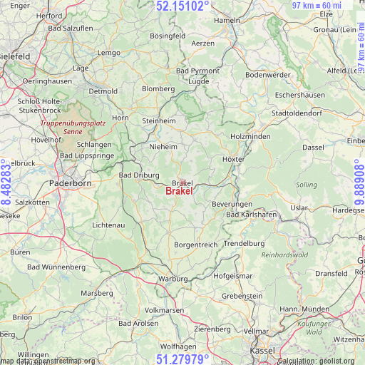
Brakel GPS coordinates[2]
51° 43' 3" North, 9° 11' 9.456" East
| Map corner | latitude | longitude |
|---|---|---|
| Upper-left | 52.15102°, | 8.48283° |
| Center: | 51.7175°, | 9.18596° |
| Lower-right: | 51.27979°, | 9.88908° |
| Map W x H: | 96.9×96.9 km | = 60.2×60.2mi |
| max Lat: | 55.01917° ⇑31% North |
| Brakel: | 51.7175° |
| min Lat: | ⇓69% South 47.40724° |
| min Long | Brakel | max Long |
| 5.92978° | 9.18596° | 14.98853° |
| W 37.4%⇐ | ⇒62.6% E |
Elevation
Elevation of Brakel is 136 m = 446 ft, and this is 113.1 m = 371 ft below average elevation for this country.
| Max E: |
1256 m = 4121 ft | 62.3% |
| Avg. | 249.1 m = 817 ft | |
| Brakel | 136 m = 446 ft | |
Min E: |
-5 m = -16 ft | 37.7% |
See also: Germany elevation on elevation.city.
Geographical zone
Brakel is located in North temperate zone (between Tropic of Cancer and the Arctic Circle). Distance of this North polar circle is 1650.7 km =1025.7 mi to North.| Distance of | km | miles | from Brakel |
|---|---|---|---|
| North Pole | 4256.6 | 2644.9 | to North |
| Arctic Circle | 1650.7 | 1025.7 | to North |
| Tropic Cancer | 3144.5 | 1953.9 | to South |
| Equator | 5750.4 | 3573.1 | to South |


Nearby cities:
15 places around Brakel: (largest is in red/bold)
• Altenbeken
17.6 km =10.9 mi,  287°
287°
• Bad Driburg
11.6 km =7.2 mi,  278°
278°
• Bad Karlshafen
20.3 km =12.6 mi,  114°
114°
• Beverungen
14.1 km =8.8 mi, 112°
• Boffzen
14.1 km =8.8 mi,  75°
75°
• Borgentreich
16.9 km =10.5 mi,  167°
167°
• Derental
17.1 km =10.6 mi,  98°
98°
• Fürstenberg
14.8 km =9.2 mi, 83°
• Holzminden
21.7 km =13.5 mi,  55°
55°
• Höxter
14.9 km =9.3 mi, 64°
• Nieheim
10.9 km =6.8 mi,  332°
332°
• Schieder-Schwalenberg
17.8 km =11.1 mi,  2°
2°
• Steinheim
18.2 km =11.3 mi,  339°
339°
• Trendelburg
22.7 km =14.1 mi,  134°
134°
• Willebadessen
14.5 km =9 mi,  225°
225°
Sources, notices
• [Note1] Compared only with cities in Germany existing in our database
• [Src1] Map data: © OpenStreetMap contributors (CC-BY-SA)
• [Src2] Other city data from geonames.org with taken over terms of usage.
• [Src3] Geographical zone / Annual Mean Temperature by Robert A. Rohde @ Wikipedia
