Rietschen geodata
Rietschen (Saxony) is a seat of a fourth-order administrative division; located in Germany in Europe/Berlin (GMT+2) time zone. With population of 3,072 people, there are 3940 cities with bigger population in this country. Compared to other cities in Germany, 64.8% of cities are located further ↓South; 99.9% of cities are located further ←West and 61.5% of cities have higher elevation than Rietschen. Note1


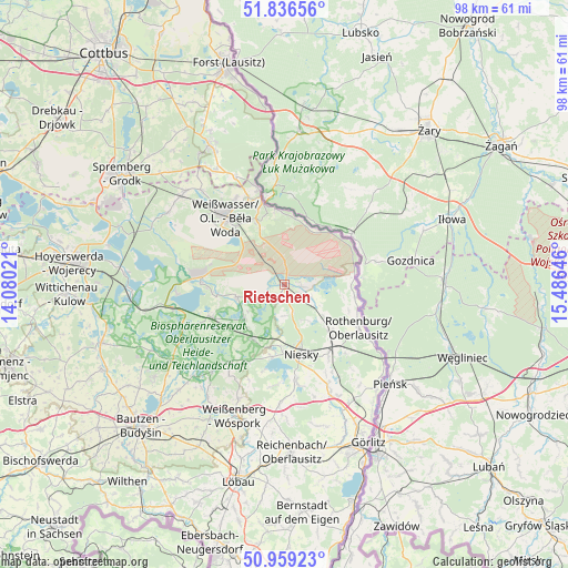
Rietschen GPS coordinates[2]
51° 24' 0" North, 14° 46' 59.988" East
| Map corner | latitude | longitude |
|---|---|---|
| Upper-left | 51.83656°, | 14.08021° |
| Center: | 51.4°, | 14.78333° |
| Lower-right: | 50.95923°, | 15.48646° |
| Map W x H: | 97.5×97.5 km | = 60.6×60.6mi |
| max Lat: | 55.01917° ⇑35.2% North |
| Rietschen: | 51.4° |
| min Lat: | ⇓64.8% South 47.40724° |
| min Long | Rietschen | max Long |
| 5.92978° | 14.78333° | 14.98853° |
| W 99.9%⇐ | ⇒0.099999999999994% E |
Elevation
Elevation of Rietschen is 142 m = 466 ft, and this is 107.1 m = 351 ft below average elevation for this country.
| Max E: |
1256 m = 4121 ft | 61.5% |
| Avg. | 249.1 m = 817 ft | |
| Rietschen | 142 m = 466 ft | |
Min E: |
-5 m = -16 ft | 38.5% |
See also: Germany elevation on elevation.city.
Geographical zone
Rietschen is located in North temperate zone (between Tropic of Cancer and the Arctic Circle). Distance of this North polar circle is 1686 km =1047.6 mi to North.| Distance of | km | miles | from Rietschen |
|---|---|---|---|
| North Pole | 4291.9 | 2666.9 | to North |
| Arctic Circle | 1686 | 1047.6 | to North |
| Tropic Cancer | 3109.2 | 1932 | to South |
| Equator | 5715.1 | 3551.2 | to South |


Nearby cities:
15 places around Rietschen: (largest is in red/bold)
• Bad Muskau
17.4 km =10.8 mi,  343°
343°
• Boxberg
14.4 km =8.9 mi,  271°
271°
• Gablenz
16.9 km =10.5 mi,  331°
331°
• Horka
13.8 km =8.6 mi,  143°
143°
• Hähnichen
6.6 km =4.1 mi,  125°
125°
• Klitten
13.5 km =8.4 mi,  246°
246°
• Kodersdorf
19.1 km =11.9 mi,  156°
156°
• Krauschwitz
14.4 km =8.9 mi, 339°
• Mücka
10.9 km =6.8 mi,  211°
211°
• Niesky
12.2 km =7.6 mi,  167°
167°
• Quitzdorf
13 km =8.1 mi,  185°
185°
• Rothenburg
14.8 km =9.2 mi,  119°
119°
• Uhyst
19.6 km =12.2 mi,  258°
258°
• Weißkeißel
11.5 km =7.1 mi, 335°
• Weißwasser
15.2 km =9.4 mi,  319°
319°
Sources, notices
• [Note1] Compared only with cities in Germany existing in our database
• [Src1] Map data: © OpenStreetMap contributors (CC-BY-SA)
• [Src2] Other city data from geonames.org with taken over terms of usage.
• [Src3] Geographical zone / Annual Mean Temperature by Robert A. Rohde @ Wikipedia
