Guttau geodata
Guttau (Saxony) is a populated place; located in Germany in Europe/Berlin (GMT+2) time zone. With population of 1,736 people, there are 5448 cities with bigger population in this country. Compared to other cities in Germany, 62.5% of cities are located further ↓South; 99.4% of cities are located further ←West and 61.1% of cities have higher elevation than Guttau. Note1


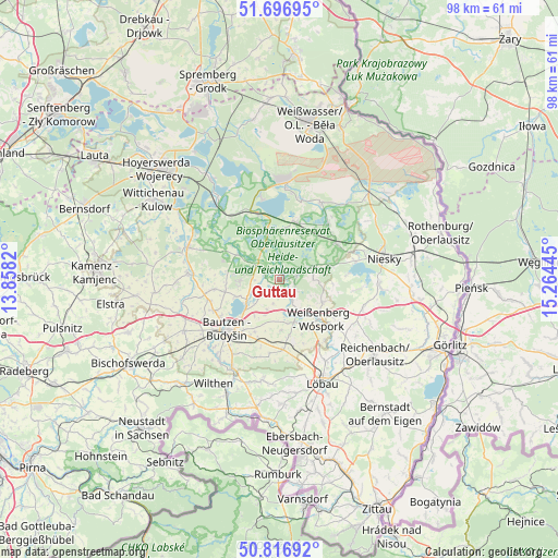
Guttau GPS coordinates[2]
51° 15' 32.544" North, 14° 33' 40.752" East
| Map corner | latitude | longitude |
|---|---|---|
| Upper-left | 51.69695°, | 13.8582° |
| Center: | 51.25904°, | 14.56132° |
| Lower-right: | 50.81692°, | 15.26445° |
| Map W x H: | 97.9×97.8 km | = 60.8×60.8mi |
| max Lat: | 55.01917° ⇑37.5% North |
| Guttau: | 51.25904° |
| min Lat: | ⇓62.5% South 47.40724° |
| min Long | Guttau | max Long |
| 5.92978° | 14.56132° | 14.98853° |
| W 99.4%⇐ | ⇒0.59999999999999% E |
Elevation
Elevation of Guttau is 145 m = 476 ft, and this is 104.1 m = 342 ft below average elevation for this country.
| Max E: |
1256 m = 4121 ft | 61.1% |
| Avg. | 249.1 m = 817 ft | |
| Guttau | 145 m = 476 ft | |
Min E: |
-5 m = -16 ft | 38.9% |
See also: Germany elevation on elevation.city.
Geographical zone
Guttau is located in North temperate zone (between Tropic of Cancer and the Arctic Circle). Distance of this North polar circle is 1701.7 km =1057.4 mi to North.| Distance of | km | miles | from Guttau |
|---|---|---|---|
| North Pole | 4307.6 | 2676.6 | to North |
| Arctic Circle | 1701.7 | 1057.4 | to North |
| Tropic Cancer | 3093.6 | 1922.3 | to South |
| Equator | 5699.5 | 3541.5 | to South |


Nearby cities:
15 places around Guttau: (largest is in red/bold)
• Bautzen
12.4 km =7.7 mi,  225°
225°
• Boxberg
16.1 km =10 mi,  3°
3°
• Großdubrau
7.1 km =4.4 mi,  265°
265°
• Großpostwitz
17.5 km =10.9 mi,  208°
208°
• Hochkirch
12.3 km =7.6 mi,  176°
176°
• Klitten
10.7 km =6.6 mi,  16°
16°
• Kubschütz
11.1 km =6.9 mi,  202°
202°
• Königswartha
17.2 km =10.7 mi,  289°
289°
• Malschwitz
3.6 km =2.2 mi, 229°
• Mücka
11.6 km =7.2 mi,  56°
56°
• Neschwitz
16.2 km =10.1 mi, 274°
• Quitzdorf
14.5 km =9 mi,  79°
79°
• Radibor
11.4 km =7.1 mi,  262°
262°
• Uhyst
12.4 km =7.7 mi,  341°
341°
• Weißenberg
9.7 km =6 mi,  135°
135°
Sources, notices
• [Note1] Compared only with cities in Germany existing in our database
• [Src1] Map data: © OpenStreetMap contributors (CC-BY-SA)
• [Src2] Other city data from geonames.org with taken over terms of usage.
• [Src3] Geographical zone / Annual Mean Temperature by Robert A. Rohde @ Wikipedia
