Holenberg geodata
Holenberg (Lower Saxony) is a seat of a fourth-order administrative division; located in Germany in Europe/Berlin (GMT+2) time zone. In our database, there are 11009 cities with bigger population. Compared to other cities in Germany, 71.2% of cities are located further ↓South; 56.5% of cities are located further →East and 62.3% of cities have lower elevation than Holenberg. Note1


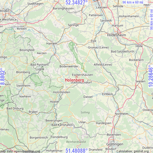
Holenberg GPS coordinates[2]
51° 55' 0.012" North, 9° 34' 59.988" East
| Map corner | latitude | longitude |
|---|---|---|
| Upper-left | 52.34827°, | 8.8802° |
| Center: | 51.91667°, | 9.58333° |
| Lower-right: | 51.48088°, | 10.28646° |
| Map W x H: | 96.4×96.4 km | = 59.9×59.9mi |
| max Lat: | 55.01917° ⇑28.8% North |
| Holenberg: | 51.91667° |
| min Lat: | ⇓71.2% South 47.40724° |
| min Long | Holenberg | max Long |
| 5.92978° | 9.58333° | 14.98853° |
| W 43.5%⇐ | ⇒56.5% E |
Elevation
Elevation of Holenberg is 304 m = 997 ft, and this is 54.9 m = 180 ft above average elevation for this country.
| Max E: |
1256 m = 4121 ft | 37.7% |
| Holenberg | 304 m 997 ft | |
| Avg. | 249.1 m = 817 ft | |
Min E: |
-5 m = -16 ft | 62.3% |
See also: Germany elevation on elevation.city.
Geographical zone
Holenberg is located in North temperate zone (between Tropic of Cancer and the Arctic Circle). Distance of this North polar circle is 1628.6 km =1012 mi to North.| Distance of | km | miles | from Holenberg |
|---|---|---|---|
| North Pole | 4234.5 | 2631.2 | to North |
| Arctic Circle | 1628.6 | 1012 | to North |
| Tropic Cancer | 3166.7 | 1967.7 | to South |
| Equator | 5772.6 | 3586.9 | to South |


Nearby cities:
15 places around Holenberg: (largest is in red/bold)
• Arholzen
5.7 km =3.5 mi,  191°
191°
• Bodenwerder
7.5 km =4.7 mi,  324°
324°
• Deensen
6.3 km =3.9 mi,  173°
173°
• Dielmissen
6.2 km =3.9 mi,  14°
14°
• Eschershausen
4.2 km =2.6 mi,  74°
74°
• Golmbach
2.9 km =1.8 mi,  230°
230°
• Halle
8.4 km =5.2 mi,  351°
351°
• Holzen
6 km =3.7 mi, 72°
• Kirchbrak
5.5 km =3.4 mi, 354°
• Lenne
7.3 km =4.5 mi,  110°
110°
• Lüerdissen
4.9 km =3 mi,  35°
35°
• Negenborn
3.9 km =2.4 mi,  197°
197°
• Pegestorf
6.1 km =3.8 mi,  281°
281°
• Stadtoldendorf
4.8 km =3 mi,  142°
142°
• Wangelnstedt
8.8 km =5.5 mi,  129°
129°
Sources, notices
• [Note1] Compared only with cities in Germany existing in our database
• [Src1] Map data: © OpenStreetMap contributors (CC-BY-SA)
• [Src2] Other city data from geonames.org with taken over terms of usage.
• [Src3] Geographical zone / Annual Mean Temperature by Robert A. Rohde @ Wikipedia
