Eschershausen geodata
Eschershausen (Lower Saxony) is a seat of a fourth-order administrative division; located in Germany in Europe/Berlin (GMT+2) time zone. With population of 3,794 people, there are 3408 cities with bigger population in this country. Compared to other cities in Germany, 71.3% of cities are located further ↓South; 55.4% of cities are located further →East and 59.7% of cities have higher elevation than Eschershausen. Note1
Administrative division(s):
- Level 1: Lower Saxony
- Level 3: Landkreis Holzminden
- Level 4: Eschershausen


Eschershausen GPS coordinates[2]
51° 55' 35.904" North, 9° 38' 34.152" East
| Map corner | latitude | longitude |
|---|---|---|
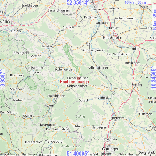
| Upper-left | 52.35814°, | 8.9397° |
| Center: | 51.92664°, | 9.64282° |
| Lower-right: | 51.49095°, | 10.34595° |
| Map W x H: | 96.4×96.4 km | = 59.9×59.9mi |
| max Lat: | 55.01917° ⇑28.7% North |
| Eschershausen: | 51.92664° |
| min Lat: | ⇓71.3% South 47.40724° |
| min Long | Eschershausen | max Long |
| 5.92978° | 9.64282° | 14.98853° |
| W 44.6%⇐ | ⇒55.4% E |
Elevation
Elevation of Eschershausen is 155 m = 509 ft, and this is 94.1 m = 309 ft below average elevation for this country.
| Max E: |
1256 m = 4121 ft | 59.7% |
| Avg. | 249.1 m = 817 ft | |
| Eschershausen | 155 m = 509 ft | |
Min E: |
-5 m = -16 ft | 40.3% |
See also: Germany elevation on elevation.city.
Geographical zone
Eschershausen is located in North temperate zone (between Tropic of Cancer and the Arctic Circle). Distance of this North polar circle is 1627.5 km =1011.3 mi to North.| Distance of | km | miles | from Eschershausen |
|---|---|---|---|
| North Pole | 4233.4 | 2630.5 | to North |
| Arctic Circle | 1627.5 | 1011.3 | to North |
| Tropic Cancer | 3167.8 | 1968.4 | to South |
| Equator | 5773.7 | 3587.6 | to South |


Nearby cities:
15 places around Eschershausen: (largest is in red/bold)
• Arholzen
8.5 km =5.3 mi,  218°
218°
• Coppengrave
8.8 km =5.5 mi,  44°
44°
• Deensen
8.1 km =5 mi,  204°
204°
• Dielmissen
5.5 km =3.4 mi,  333°
333°
• Duingen
9.4 km =5.8 mi,  22°
22°
• Golmbach
7 km =4.3 mi,  245°
245°
• Halle
8.9 km =5.5 mi,  323°
323°
• Holenberg
4.2 km =2.6 mi, 254°
• Holzen
1.8 km =1.1 mi,  65°
65°
• Kirchbrak
6.4 km =4 mi,  313°
313°
• Lenne
4.6 km =2.9 mi,  142°
142°
• Lüerdissen
3.2 km =2 mi,  336°
336°
• Negenborn
7.1 km =4.4 mi,  227°
227°
• Stadtoldendorf
5 km =3.1 mi,  192°
192°
• Wangelnstedt
7.2 km =4.5 mi,  157°
157°
Sources, notices
• [Note1] Compared only with cities in Germany existing in our database
• [Src1] Map data: © OpenStreetMap contributors (CC-BY-SA)
• [Src2] Other city data from geonames.org with taken over terms of usage.
• [Src3] Geographical zone / Annual Mean Temperature by Robert A. Rohde @ Wikipedia
