Hirschhorn geodata
Hirschhorn (Rheinland-Pfalz) is a populated place; located in Germany in Europe/Berlin (GMT+2) time zone. With population of 799 people, there are 7902 cities with bigger population in this country. Compared to other cities in Germany, 75.3% of cities are located further ↑North; 83.4% of cities are located further →East and 50.9% of cities have higher elevation than Hirschhorn. Note1
Administrative division(s):
- Level 1: Rheinland-Pfalz
- Level 3: Landkreis Kaiserslautern
- Level 4: Hirschhorn/ Pfalz


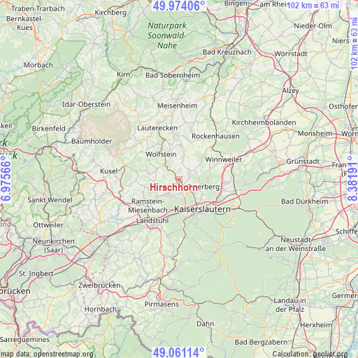
Hirschhorn GPS coordinates[2]
49° 31' 11.028" North, 7° 40' 43.644" East
| Map corner | latitude | longitude |
|---|---|---|
| Upper-left | 49.97406°, | 6.97566° |
| Center: | 49.51973°, | 7.67879° |
| Lower-right: | 49.06114°, | 8.38191° |
| Map W x H: | 101.5×101.5 km | = 63.1×63.1mi |
| max Lat: | 55.01917° ⇑75.3% North |
| Hirschhorn: | 49.51973° |
| min Lat: | ⇓24.7% South 47.40724° |
| min Long | Hirschhorn | max Long |
| 5.92978° | 7.67879° | 14.98853° |
| W 16.6%⇐ | ⇒83.4% E |
Elevation
Elevation of Hirschhorn is 219 m = 719 ft, and this is 30.1 m = 99 ft below average elevation for this country.
| Max E: |
1256 m = 4121 ft | 50.9% |
| Avg. | 249.1 m = 817 ft | |
| Hirschhorn | 219 m = 719 ft | |
Min E: |
-5 m = -16 ft | 49.1% |
See also: Germany elevation on elevation.city.
Geographical zone
Hirschhorn is located in North temperate zone (between Tropic of Cancer and the Arctic Circle). Distance of this North polar circle is 1895.1 km =1177.6 mi to North.| Distance of | km | miles | from Hirschhorn |
|---|---|---|---|
| North Pole | 4501 | 2796.8 | to North |
| Arctic Circle | 1895.1 | 1177.6 | to North |
| Tropic Cancer | 2900.2 | 1802.1 | to South |
| Equator | 5506.1 | 3421.3 | to South |


Nearby cities:
15 places around Hirschhorn: (largest is in red/bold)
• Erzenhausen
5 km =3.1 mi,  243°
243°
• Eulenbis
3.9 km =2.4 mi, 236°
• Frankelbach
3.6 km =2.2 mi,  294°
294°
• Katzweiler
2.7 km =1.7 mi,  145°
145°
• Kreimbach-Kaulbach
4.7 km =2.9 mi,  315°
315°
• Mehlbach
2.8 km =1.7 mi,  97°
97°
• Olsbrücken
2.6 km =1.6 mi,  325°
325°
• Otterbach
5.5 km =3.4 mi,  133°
133°
• Otterberg
6.8 km =4.2 mi,  105°
105°
• Rodenbach
5.4 km =3.4 mi,  196°
196°
• Rothselberg
6.6 km =4.1 mi,  300°
300°
• Schallodenbach
4.3 km =2.7 mi,  39°
39°
• Schneckenhausen
5.2 km =3.2 mi,  66°
66°
• Schwedelbach
6.7 km =4.2 mi,  246°
246°
• Weilerbach
5.2 km =3.2 mi,  219°
219°
Sources, notices
• [Note1] Compared only with cities in Germany existing in our database
• [Src1] Map data: © OpenStreetMap contributors (CC-BY-SA)
• [Src2] Other city data from geonames.org with taken over terms of usage.
• [Src3] Geographical zone / Annual Mean Temperature by Robert A. Rohde @ Wikipedia
