Schwedelbach geodata
Schwedelbach (Rheinland-Pfalz) is a seat of a fourth-order administrative division; located in Germany in Europe/Berlin (GMT+2) time zone. With population of 1,119 people, there are 6795 cities with bigger population in this country. Compared to other cities in Germany, 75.8% of cities are located further ↑North; 85.1% of cities are located further →East and 54.2% of cities have lower elevation than Schwedelbach. Note1
Administrative division(s):
- Level 1: Rheinland-Pfalz
- Level 3: Landkreis Kaiserslautern
- Level 4: Schwedelbach


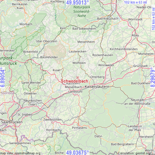
Schwedelbach GPS coordinates[2]
49° 29' 44.052" North, 7° 35' 37.176" East
| Map corner | latitude | longitude |
|---|---|---|
| Upper-left | 49.95013°, | 6.89054° |
| Center: | 49.49557°, | 7.59366° |
| Lower-right: | 49.03675°, | 8.29679° |
| Map W x H: | 101.6×101.6 km | = 63.1×63.1mi |
| max Lat: | 55.01917° ⇑75.8% North |
| Schwedelbach: | 49.49557° |
| min Lat: | ⇓24.2% South 47.40724° |
| min Long | Schwedelbach | max Long |
| 5.92978° | 7.59366° | 14.98853° |
| W 14.9%⇐ | ⇒85.1% E |
Elevation
Elevation of Schwedelbach is 253 m = 830 ft, and this is 3.9 m = 13 ft above average elevation for this country.
| Max E: |
1256 m = 4121 ft | 45.8% |
| Schwedelbach | 253 m 830 ft | |
| Avg. | 249.1 m = 817 ft | |
Min E: |
-5 m = -16 ft | 54.2% |
See also: Germany elevation on elevation.city.
Geographical zone
Schwedelbach is located in North temperate zone (between Tropic of Cancer and the Arctic Circle). Distance of this North polar circle is 1897.8 km =1179.2 mi to North.| Distance of | km | miles | from Schwedelbach |
|---|---|---|---|
| North Pole | 4503.7 | 2798.5 | to North |
| Arctic Circle | 1897.8 | 1179.2 | to North |
| Tropic Cancer | 2897.5 | 1800.4 | to South |
| Equator | 5503.4 | 3419.7 | to South |


Nearby cities:
15 places around Schwedelbach: (largest is in red/bold)
• Erzenhausen
1.7 km =1.1 mi,  73°
73°
• Eulenbis
2.9 km =1.8 mi,  80°
80°
• Frankelbach
5.1 km =3.2 mi,  34°
34°
• Jettenbach
5.1 km =3.2 mi,  328°
328°
• Kollweiler
2.5 km =1.6 mi,  342°
342°
• Kottweiler-Schwanden
4.6 km =2.9 mi,  252°
252°
• Kreimbach-Kaulbach
6.7 km =4.2 mi, 25°
• Mackenbach
3.3 km =2.1 mi,  193°
193°
• Oberstaufenbach
6.5 km =4 mi,  290°
290°
• Ramstein-Miesenbach
6.3 km =3.9 mi,  206°
206°
• Reichenbach-Steegen
3.2 km =2 mi,  278°
278°
• Rodenbach
5.3 km =3.3 mi,  118°
118°
• Rothselberg
6.1 km =3.8 mi,  4°
4°
• Steinwenden
6.4 km =4 mi,  228°
228°
• Weilerbach
3.2 km =2 mi, 115°
Sources, notices
• [Note1] Compared only with cities in Germany existing in our database
• [Src1] Map data: © OpenStreetMap contributors (CC-BY-SA)
• [Src2] Other city data from geonames.org with taken over terms of usage.
• [Src3] Geographical zone / Annual Mean Temperature by Robert A. Rohde @ Wikipedia
