Sulzbach-Rosenberg geodata
Sulzbach-Rosenberg (Bavaria) is a populated place; located in Germany in Europe/Berlin (GMT+2) time zone. With population of 20,780 people, there are 738 cities with bigger population in this country. Compared to other cities in Germany, 75.7% of cities are located further ↑North; 77.9% of cities are located further ←West and 75.2% of cities have lower elevation than Sulzbach-Rosenberg. Note1
Administrative division(s):
- Level 1: Bavaria
- Level 2: Upper Palatinate
- Level 3: Landkreis Amberg-Sulzbach
- Level 4: Sulzbach-Rosenberg


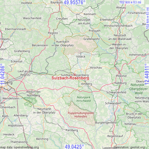
Sulzbach-Rosenberg GPS coordinates[2]
49° 30' 4.536" North, 11° 44' 45.528" East
| Map corner | latitude | longitude |
|---|---|---|
| Upper-left | 49.95576°, | 11.04286° |
| Center: | 49.50126°, | 11.74598° |
| Lower-right: | 49.0425°, | 12.44911° |
| Map W x H: | 101.5×101.5 km | = 63.1×63.1mi |
| max Lat: | 55.01917° ⇑75.7% North |
| Sulzbach-Rosenberg: | 49.50126° |
| min Lat: | ⇓24.3% South 47.40724° |
| min Long | Sulzbach-Rosenb | max Long |
| 5.92978° | 11.74598° | 14.98853° |
| W 77.9%⇐ | ⇒22.1% E |
Elevation
Elevation of Sulzbach-Rosenberg is 399 m = 1309 ft, and this is 149.9 m = 492 ft above average elevation for this country.
| Max E: |
1256 m = 4121 ft | 24.8% |
| Sulzbach-Rosenberg | 399 m 1309 ft | |
| Avg. | 249.1 m = 817 ft | |
Min E: |
-5 m = -16 ft | 75.2% |
See also: Germany elevation on elevation.city.
Geographical zone
Sulzbach-Rosenberg is located in North temperate zone (between Tropic of Cancer and the Arctic Circle). Distance of this North polar circle is 1897.1 km =1178.8 mi to North.| Distance of | km | miles | from Sulzbach-Rosenberg |
|---|---|---|---|
| North Pole | 4503 | 2798 | to North |
| Arctic Circle | 1897.1 | 1178.8 | to North |
| Tropic Cancer | 2898.1 | 1800.8 | to South |
| Equator | 5504 | 3420 | to South |


Nearby cities:
15 places around Sulzbach-Rosenberg: (largest is in red/bold)
• Amberg
10.6 km =6.6 mi,  127°
127°
• Ammerthal
6.8 km =4.2 mi,  170°
170°
• Edelsfeld
9.1 km =5.7 mi,  336°
336°
• Etzelwang
11.9 km =7.4 mi,  284°
284°
• Gebenbach
10 km =6.2 mi,  66°
66°
• Hahnbach
5.5 km =3.4 mi,  48°
48°
• Hirschau
15.2 km =9.4 mi, 71°
• Illschwang
7.3 km =4.5 mi,  218°
218°
• Kastl
15.3 km =9.5 mi,  197°
197°
• Königstein
14.5 km =9 mi,  325°
325°
• Kümmersbruck
13.8 km =8.6 mi, 131°
• Poppenricht
4.7 km =2.9 mi, 127°
• Ursensollen
11.1 km =6.9 mi,  176°
176°
• Vilseck
13.3 km =8.3 mi,  17°
17°
• Weigendorf
12.8 km =8 mi,  268°
268°
Sources, notices
• [Note1] Compared only with cities in Germany existing in our database
• [Src1] Map data: © OpenStreetMap contributors (CC-BY-SA)
• [Src2] Other city data from geonames.org with taken over terms of usage.
• [Src3] Geographical zone / Annual Mean Temperature by Robert A. Rohde @ Wikipedia
