Heyersum geodata
Heyersum (Lower Saxony) is a populated place; located in Germany in Europe/Berlin (GMT+2) time zone. With population of 1,089 people, there are 6878 cities with bigger population in this country. Compared to other cities in Germany, 73.6% of cities are located further ↓South; 52.6% of cities are located further →East and 69.2% of cities have higher elevation than Heyersum. Note1
Administrative division(s):
- Level 1: Lower Saxony
- Level 3: Landkreis Hildesheim
- Level 4: Nordstemmen


Heyersum GPS coordinates[2]
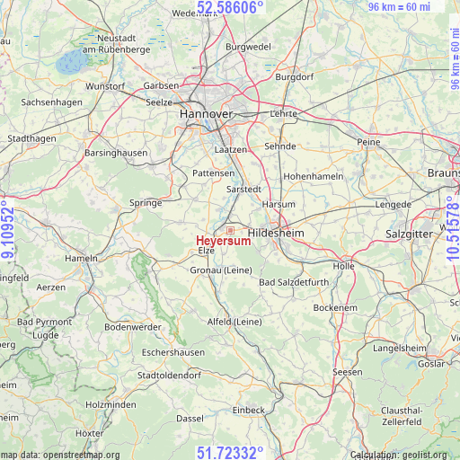
52° 9' 24.408" North, 9° 48' 45.54" East
| Map corner | latitude | longitude |
|---|---|---|
| Upper-left | 52.58606°, | 9.10952° |
| Center: | 52.15678°, | 9.81265° |
| Lower-right: | 51.72332°, | 10.51578° |
| Map W x H: | 95.9×95.9 km | = 59.6×59.6mi |
| max Lat: | 55.01917° ⇑26.4% North |
| Heyersum: | 52.15678° |
| min Lat: | ⇓73.6% South 47.40724° |
| min Long | Heyersum | max Long |
| 5.92978° | 9.81265° | 14.98853° |
| W 47.4%⇐ | ⇒52.6% E |
Elevation
Elevation of Heyersum is 96 m = 315 ft, and this is 153.1 m = 502 ft below average elevation for this country.
| Max E: |
1256 m = 4121 ft | 69.2% |
| Avg. | 249.1 m = 817 ft | |
| Heyersum | 96 m = 315 ft | |
Min E: |
-5 m = -16 ft | 30.8% |
See also: Germany elevation on elevation.city.
Geographical zone
Heyersum is located in North temperate zone (between Tropic of Cancer and the Arctic Circle). Distance of this North polar circle is 1601.9 km =995.4 mi to North.| Distance of | km | miles | from Heyersum |
|---|---|---|---|
| North Pole | 4207.8 | 2614.6 | to North |
| Arctic Circle | 1601.9 | 995.4 | to North |
| Tropic Cancer | 3193.4 | 1984.3 | to South |
| Equator | 5799.3 | 3603.5 | to South |


Nearby cities:
15 places around Heyersum: (largest is in red/bold)
• Banteln
10.9 km =6.8 mi,  203°
203°
• Betheln
4.9 km =3 mi, 195°
• Brüggen
13 km =8.1 mi,  191°
191°
• Diekholzen
9.9 km =6.2 mi,  132°
132°
• Eberholzen
12.1 km =7.5 mi,  167°
167°
• Eime
11.1 km =6.9 mi,  214°
214°
• Elze
6.5 km =4 mi,  234°
234°
• Giesen
7.4 km =4.6 mi,  52°
52°
• Gronau
8.4 km =5.2 mi, 196°
• Harsum
12 km =7.5 mi,  60°
60°
• Hildesheim
9.5 km =5.9 mi,  94°
94°
• Nordstemmen
2.1 km =1.3 mi,  286°
286°
• Pattensen
12.4 km =7.7 mi,  344°
344°
• Rheden
11.1 km =6.9 mi, 188°
• Sarstedt
9.1 km =5.7 mi,  18°
18°
Sources, notices
• [Note1] Compared only with cities in Germany existing in our database
• [Src1] Map data: © OpenStreetMap contributors (CC-BY-SA)
• [Src2] Other city data from geonames.org with taken over terms of usage.
• [Src3] Geographical zone / Annual Mean Temperature by Robert A. Rohde @ Wikipedia
