Elze geodata
Elze (Lower Saxony) is a seat of a fourth-order administrative division; located in Germany in Europe/Berlin (GMT+2) time zone. With population of 9,582 people, there are 1687 cities with bigger population in this country. Compared to other cities in Germany, 73.3% of cities are located further ↓South; 53.7% of cities are located further →East and 69.7% of cities have higher elevation than Elze. Note1


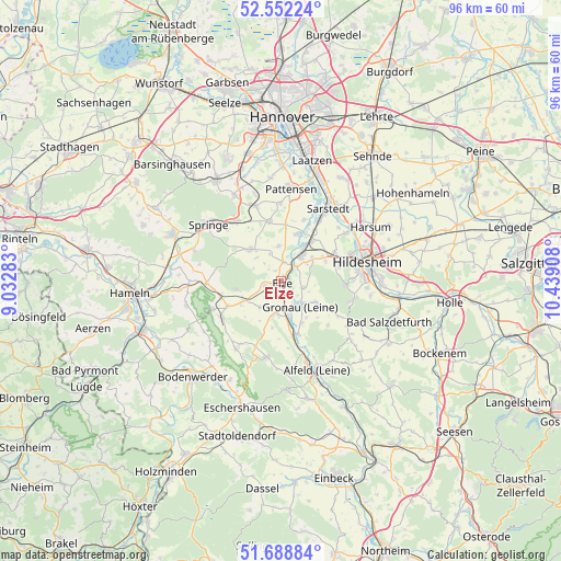
Elze GPS coordinates[2]
52° 7' 21.468" North, 9° 44' 9.42" East
| Map corner | latitude | longitude |
|---|---|---|
| Upper-left | 52.55224°, | 9.03283° |
| Center: | 52.12263°, | 9.73595° |
| Lower-right: | 51.68884°, | 10.43908° |
| Map W x H: | 96×96 km | = 59.7×59.7mi |
| max Lat: | 55.01917° ⇑26.7% North |
| Elze: | 52.12263° |
| min Lat: | ⇓73.3% South 47.40724° |
| min Long | Elze | max Long |
| 5.92978° | 9.73595° | 14.98853° |
| W 46.3%⇐ | ⇒53.7% E |
Elevation
Elevation of Elze is 93 m = 305 ft, and this is 156.1 m = 512 ft below average elevation for this country.
| Max E: |
1256 m = 4121 ft | 69.7% |
| Avg. | 249.1 m = 817 ft | |
| Elze | 93 m = 305 ft | |
Min E: |
-5 m = -16 ft | 30.3% |
See also: Germany elevation on elevation.city.
Geographical zone
Elze is located in North temperate zone (between Tropic of Cancer and the Arctic Circle). Distance of this North polar circle is 1605.7 km =997.7 mi to North.| Distance of | km | miles | from Elze |
|---|---|---|---|
| North Pole | 4211.6 | 2617 | to North |
| Arctic Circle | 1605.7 | 997.7 | to North |
| Tropic Cancer | 3189.6 | 1981.9 | to South |
| Equator | 5795.5 | 3601.2 | to South |


Nearby cities:
15 places around Elze: (largest is in red/bold)
• Banteln
6.3 km =3.9 mi,  171°
171°
• Betheln
4.1 km =2.5 mi,  103°
103°
• Brüggen
9.3 km =5.8 mi,  163°
163°
• Coppenbrügge
12.8 km =8 mi,  267°
267°
• Eberholzen
11.2 km =7 mi,  136°
136°
• Eime
5.4 km =3.4 mi,  190°
190°
• Gronau
5.1 km =3.2 mi,  146°
146°
• Heinsen
8.3 km =5.2 mi,  216°
216°
• Heyersum
6.5 km =4 mi,  54°
54°
• Hoyershausen
11.6 km =7.2 mi, 174°
• Marienhagen
10.1 km =6.3 mi,  199°
199°
• Nordstemmen
5.4 km =3.4 mi,  36°
36°
• Rheden
8 km =5 mi, 154°
• Salzhemmendorf
11.9 km =7.4 mi,  238°
238°
• Weenzen
11 km =6.8 mi,  205°
205°
Sources, notices
• [Note1] Compared only with cities in Germany existing in our database
• [Src1] Map data: © OpenStreetMap contributors (CC-BY-SA)
• [Src2] Other city data from geonames.org with taken over terms of usage.
• [Src3] Geographical zone / Annual Mean Temperature by Robert A. Rohde @ Wikipedia
