Harsum geodata
Harsum (Lower Saxony) is a seat of a fourth-order administrative division; located in Germany in Europe/Berlin (GMT+2) time zone. With population of 12,331 people, there are 1324 cities with bigger population in this country. Compared to other cities in Germany, 74.2% of cities are located further ↓South; 50.6% of cities are located further →East and 71.5% of cities have higher elevation than Harsum. Note1


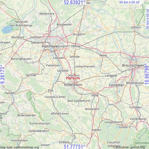
Harsum GPS coordinates[2]
52° 12' 37.62" North, 9° 57' 53.496" East
| Map corner | latitude | longitude |
|---|---|---|
| Upper-left | 52.63921°, | 9.26173° |
| Center: | 52.21045°, | 9.96486° |
| Lower-right: | 51.77751°, | 10.66799° |
| Map W x H: | 95.8×95.8 km | = 59.5×59.5mi |
| max Lat: | 55.01917° ⇑25.8% North |
| Harsum: | 52.21045° |
| min Lat: | ⇓74.2% South 47.40724° |
| min Long | Harsum | max Long |
| 5.92978° | 9.96486° | 14.98853° |
| W 49.4%⇐ | ⇒50.6% E |
Elevation
Elevation of Harsum is 81 m = 266 ft, and this is 168.1 m = 552 ft below average elevation for this country.
| Max E: |
1256 m = 4121 ft | 71.5% |
| Avg. | 249.1 m = 817 ft | |
| Harsum | 81 m = 266 ft | |
Min E: |
-5 m = -16 ft | 28.5% |
See also: Germany elevation on elevation.city.
Geographical zone
Harsum is located in North temperate zone (between Tropic of Cancer and the Arctic Circle). Distance of this North polar circle is 1595.9 km =991.6 mi to North.| Distance of | km | miles | from Harsum |
|---|---|---|---|
| North Pole | 4201.8 | 2610.9 | to North |
| Arctic Circle | 1595.9 | 991.6 | to North |
| Tropic Cancer | 3199.3 | 1988 | to South |
| Equator | 5805.3 | 3607.2 | to South |


Nearby cities:
15 places around Harsum: (largest is in red/bold)
• Algermissen
4.8 km =3 mi,  3°
3°
• Bad Salzdetfurth
17.2 km =10.7 mi,  170°
170°
• Betheln
15.8 km =9.8 mi,  227°
227°
• Diekholzen
13.1 km =8.1 mi,  193°
193°
• Giesen
4.7 km =2.9 mi,  251°
251°
• Heyersum
12 km =7.5 mi,  240°
240°
• Hildesheim
6.7 km =4.2 mi, 188°
• Hohenhameln
8.6 km =5.3 mi,  52°
52°
• Ilsede
17 km =10.6 mi,  69°
69°
• Laatzen
16.3 km =10.1 mi,  315°
315°
• Nordstemmen
13.5 km =8.4 mi, 246°
• Pattensen
14.9 km =9.3 mi,  293°
293°
• Sarstedt
8 km =5 mi, 289°
• Schellerten
9.8 km =6.1 mi,  106°
106°
• Sehnde
11.5 km =7.1 mi, 1°
Sources, notices
• [Note1] Compared only with cities in Germany existing in our database
• [Src1] Map data: © OpenStreetMap contributors (CC-BY-SA)
• [Src2] Other city data from geonames.org with taken over terms of usage.
• [Src3] Geographical zone / Annual Mean Temperature by Robert A. Rohde @ Wikipedia
