Heroldsberg geodata
Heroldsberg (Bavaria) is a populated place; located in Germany in Europe/Berlin (GMT+2) time zone. With population of 7,429 people, there are 2087 cities with bigger population in this country. Compared to other cities in Germany, 75.2% of cities are located further ↑North; 69.2% of cities are located further ←West and 71.4% of cities have lower elevation than Heroldsberg. Note1
Administrative division(s):
- Level 1: Bavaria
- Level 2: Regierungsbezirk Mittelfranken
- Level 3: Landkreis Erlangen-Höchstadt
- Level 4: Heroldsberg, Markt


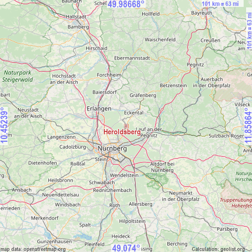
Heroldsberg GPS coordinates[2]
49° 31' 56.892" North, 11° 9' 19.836" East
| Map corner | latitude | longitude |
|---|---|---|
| Upper-left | 49.98668°, | 10.45239° |
| Center: | 49.53247°, | 11.15551° |
| Lower-right: | 49.074°, | 11.85864° |
| Map W x H: | 101.5×101.5 km | = 63.1×63.1mi |
| max Lat: | 55.01917° ⇑75.2% North |
| Heroldsberg: | 49.53247° |
| min Lat: | ⇓24.8% South 47.40724° |
| min Long | Heroldsberg | max Long |
| 5.92978° | 11.15551° | 14.98853° |
| W 69.2%⇐ | ⇒30.8% E |
Elevation
Elevation of Heroldsberg is 369 m = 1211 ft, and this is 119.9 m = 393 ft above average elevation for this country.
| Max E: |
1256 m = 4121 ft | 28.6% |
| Heroldsberg | 369 m 1211 ft | |
| Avg. | 249.1 m = 817 ft | |
Min E: |
-5 m = -16 ft | 71.4% |
See also: Germany elevation on elevation.city.
Geographical zone
Heroldsberg is located in North temperate zone (between Tropic of Cancer and the Arctic Circle). Distance of this North polar circle is 1893.7 km =1176.7 mi to North.| Distance of | km | miles | from Heroldsberg |
|---|---|---|---|
| North Pole | 4499.6 | 2795.9 | to North |
| Arctic Circle | 1893.7 | 1176.7 | to North |
| Tropic Cancer | 2901.6 | 1803 | to South |
| Equator | 5507.5 | 3422.2 | to South |


Nearby cities:
15 places around Heroldsberg: (largest is in red/bold)
• Buckenhof
10.2 km =6.3 mi,  311°
311°
• Dormitz
7.8 km =4.8 mi,  339°
339°
• Hetzles
11.3 km =7 mi,  351°
351°
• Igensdorf
11.5 km =7.1 mi,  28°
28°
• Kalchreuth
3.2 km =2 mi,  330°
330°
• Kleinsendelbach
7 km =4.3 mi,  1°
1°
• Lauf an der Pegnitz
9.4 km =5.8 mi,  102°
102°
• Neunkirchen am Brand
9 km =5.6 mi, 348°
• Nürnberg
10.4 km =6.5 mi,  212°
212°
• Röthenbach an der Pegnitz
8.3 km =5.2 mi,  131°
131°
• Rückersdorf
7.7 km =4.8 mi,  120°
120°
• Schwaig
7.7 km =4.8 mi,  155°
155°
• Spardorf
11.1 km =6.9 mi,  319°
319°
• Uttenreuth
9.3 km =5.8 mi, 319°
• Wetzendorf
10.7 km =6.6 mi,  230°
230°
Sources, notices
• [Note1] Compared only with cities in Germany existing in our database
• [Src1] Map data: © OpenStreetMap contributors (CC-BY-SA)
• [Src2] Other city data from geonames.org with taken over terms of usage.
• [Src3] Geographical zone / Annual Mean Temperature by Robert A. Rohde @ Wikipedia
