Schwaig geodata
Schwaig (Bavaria) is a populated place; located in Germany in Europe/Berlin (GMT+2) time zone. With population of 8,340 people, there are 1897 cities with bigger population in this country. Compared to other cities in Germany, 76.2% of cities are located further ↑North; 70% of cities are located further ←West and 65.4% of cities have lower elevation than Schwaig. Note1
Administrative division(s):
- Level 1: Bavaria
- Level 2: Regierungsbezirk Mittelfranken
- Level 3: Nürnberger Land
- Level 4: Schwaig b.Nürnberg


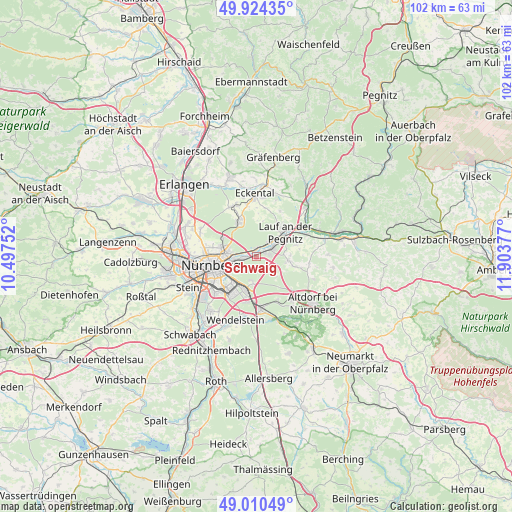
Schwaig GPS coordinates[2]
49° 28' 10.38" North, 11° 12' 2.304" East
| Map corner | latitude | longitude |
|---|---|---|
| Upper-left | 49.92435°, | 10.49752° |
| Center: | 49.46955°, | 11.20064° |
| Lower-right: | 49.01049°, | 11.90377° |
| Map W x H: | 101.6×101.6 km | = 63.1×63.1mi |
| max Lat: | 55.01917° ⇑76.2% North |
| Schwaig: | 49.46955° |
| min Lat: | ⇓23.8% South 47.40724° |
| min Long | Schwaig | max Long |
| 5.92978° | 11.20064° | 14.98853° |
| W 70%⇐ | ⇒30% E |
Elevation
Elevation of Schwaig is 324 m = 1063 ft, and this is 74.9 m = 246 ft above average elevation for this country.
| Max E: |
1256 m = 4121 ft | 34.6% |
| Schwaig | 324 m 1063 ft | |
| Avg. | 249.1 m = 817 ft | |
Min E: |
-5 m = -16 ft | 65.4% |
See also: Germany elevation on elevation.city.
Geographical zone
Schwaig is located in North temperate zone (between Tropic of Cancer and the Arctic Circle). Distance of this North polar circle is 1900.7 km =1181 mi to North.| Distance of | km | miles | from Schwaig |
|---|---|---|---|
| North Pole | 4506.6 | 2800.3 | to North |
| Arctic Circle | 1900.7 | 1181 | to North |
| Tropic Cancer | 2894.6 | 1798.6 | to South |
| Equator | 5500.5 | 3417.9 | to South |


Nearby cities:
15 places around Schwaig: (largest is in red/bold)
• Feucht
10.5 km =6.5 mi,  174°
174°
• Großreuth bei Schweinau
13.4 km =8.3 mi,  253°
253°
• Heroldsberg
7.7 km =4.8 mi,  335°
335°
• Kalchreuth
10.9 km =6.8 mi,  333°
333°
• Lauf an der Pegnitz
7.7 km =4.8 mi,  50°
50°
• Leinburg
8.1 km =5 mi,  104°
104°
• Neunkirchen am Sand
10.5 km =6.5 mi, 54°
• Nürnberg
9.1 km =5.7 mi,  259°
259°
• Ottensoos
11.1 km =6.9 mi,  66°
66°
• Reichenschwand
13.4 km =8.3 mi, 68°
• Röthenbach an der Pegnitz
3.3 km =2.1 mi,  62°
62°
• Rückersdorf
4.6 km =2.9 mi, 47°
• Schwarzenbruck
12.8 km =8 mi, 166°
• Wetzendorf
11.5 km =7.1 mi,  270°
270°
• Winkelhaid
11.4 km =7.1 mi,  141°
141°
Sources, notices
• [Note1] Compared only with cities in Germany existing in our database
• [Src1] Map data: © OpenStreetMap contributors (CC-BY-SA)
• [Src2] Other city data from geonames.org with taken over terms of usage.
• [Src3] Geographical zone / Annual Mean Temperature by Robert A. Rohde @ Wikipedia
