Röthenbach an der Pegnitz geodata
Röthenbach an der Pegnitz (Bavaria) is a populated place; located in Germany in Europe/Berlin (GMT+2) time zone. With population of 12,224 people, there are 1338 cities with bigger population in this country. Compared to other cities in Germany, 76.1% of cities are located further ↑North; 70.5% of cities are located further ←West and 66.4% of cities have lower elevation than Röthenbach an der Pegnitz. Note1
Administrative division(s):
- Level 1: Bavaria
- Level 2: Regierungsbezirk Mittelfranken
- Level 3: Nürnberger Land
- Level 4: Röthenbach a.d.Pegnitz
Current local time in Röthenbach an der Pegnitz:
02:55 AM, SaturdayDifference from your time zone: hours


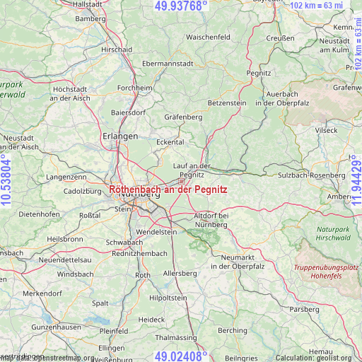
Röthenbach an der Pegnitz GPS coordinates[2]
49° 28' 58.836" North, 11° 14' 28.176" East
| Map corner | latitude | longitude |
|---|---|---|
| Upper-left | 49.93768°, | 10.53804° |
| Center: | 49.48301°, | 11.24116° |
| Lower-right: | 49.02408°, | 11.94429° |
| Map W x H: | 101.6×101.6 km | = 63.1×63.1mi |
| max Lat: | 55.01917° ⇑76.1% North |
| Röthenbach an der Pegnitz: | 49.48301° |
| min Lat: | ⇓23.9% South 47.40724° |
| min Long | Röthenbach an | max Long |
| 5.92978° | 11.24116° | 14.98853° |
| W 70.5%⇐ | ⇒29.5% E |
Elevation
Elevation of Röthenbach an der Pegnitz is 331 m = 1086 ft, and this is 81.9 m = 269 ft above average elevation for this country.
| Max E: |
1256 m = 4121 ft | 33.6% |
| Röthenbach an der Pegnitz | 331 m 1086 ft | |
| Avg. | 249.1 m = 817 ft | |
Min E: |
-5 m = -16 ft | 66.4% |
See also: Germany elevation on elevation.city.
Geographical zone
Röthenbach an der Pegnitz is located in North temperate zone (between Tropic of Cancer and the Arctic Circle). Distance of this North polar circle is 1899.2 km =1180.1 mi to North.| Distance of | km | miles | from Röthenbach an der Pegnitz |
|---|---|---|---|
| North Pole | 4505.1 | 2799.3 | to North |
| Arctic Circle | 1899.2 | 1180.1 | to North |
| Tropic Cancer | 2896.1 | 1799.6 | to South |
| Equator | 5502 | 3418.8 | to South |


Nearby cities:
15 places around Röthenbach an der Pegnitz: (largest is in red/bold)
• Engelthal
11.5 km =7.1 mi,  96°
96°
• Feucht
12.1 km =7.5 mi,  189°
189°
• Henfenfeld
10.9 km =6.8 mi,  80°
80°
• Heroldsberg
8.3 km =5.2 mi,  311°
311°
• Kalchreuth
11.4 km =7.1 mi,  316°
316°
• Lauf an der Pegnitz
4.5 km =2.8 mi,  41°
41°
• Leinburg
6.1 km =3.8 mi,  125°
125°
• Neunkirchen am Sand
7.3 km =4.5 mi,  50°
50°
• Nürnberg
12.3 km =7.6 mi,  254°
254°
• Ottensoos
7.8 km =4.8 mi,  67°
67°
• Reichenschwand
10.1 km =6.3 mi, 70°
• Rückersdorf
1.7 km =1.1 mi,  15°
15°
• Schnaittach
11.3 km =7 mi, 40°
• Schwaig
3.3 km =2.1 mi,  242°
242°
• Winkelhaid
11.2 km =7 mi,  158°
158°
Sources, notices
• [Note1] Compared only with cities in Germany existing in our database
• [Src1] Map data: © OpenStreetMap contributors (CC-BY-SA)
• [Src2] Other city data from geonames.org with taken over terms of usage.
• [Src3] Geographical zone / Annual Mean Temperature by Robert A. Rohde @ Wikipedia
