Hermsdorf geodata
Hermsdorf (Brandenburg) is a populated place; located in Germany in Europe/Berlin (GMT+2) time zone. With population of 932 people, there are 7414 cities with bigger population in this country. Compared to other cities in Germany, 73.6% of cities are located further ↓South; 97.3% of cities are located further ←West and 81.4% of cities have higher elevation than Hermsdorf. Note1
Administrative division(s):
- Level 1: Brandenburg
- Level 3: Landkreis Dahme-Spreewald
- Level 4: Münchehofe


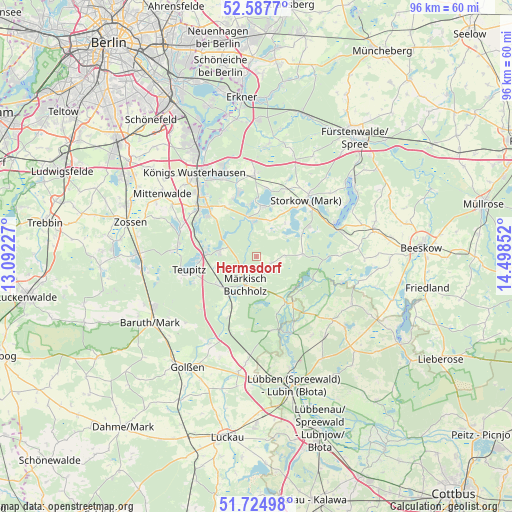
Hermsdorf GPS coordinates[2]
52° 9' 30.348" North, 13° 47' 43.404" East
| Map corner | latitude | longitude |
|---|---|---|
| Upper-left | 52.5877°, | 13.09227° |
| Center: | 52.15843°, | 13.79539° |
| Lower-right: | 51.72498°, | 14.49852° |
| Map W x H: | 95.9×95.9 km | = 59.6×59.6mi |
| max Lat: | 55.01917° ⇑26.4% North |
| Hermsdorf: | 52.15843° |
| min Lat: | ⇓73.6% South 47.40724° |
| min Long | Hermsdorf | max Long |
| 5.92978° | 13.79539° | 14.98853° |
| W 97.3%⇐ | ⇒2.7% E |
Elevation
Elevation of Hermsdorf is 43 m = 141 ft, and this is 206.1 m = 676 ft below average elevation for this country.
| Max E: |
1256 m = 4121 ft | 81.4% |
| Avg. | 249.1 m = 817 ft | |
| Hermsdorf | 43 m = 141 ft | |
Min E: |
-5 m = -16 ft | 18.6% |
See also: Germany elevation on elevation.city.
Geographical zone
Hermsdorf is located in North temperate zone (between Tropic of Cancer and the Arctic Circle). Distance of this North polar circle is 1601.7 km =995.2 mi to North.| Distance of | km | miles | from Hermsdorf |
|---|---|---|---|
| North Pole | 4207.6 | 2614.5 | to North |
| Arctic Circle | 1601.7 | 995.2 | to North |
| Tropic Cancer | 3193.6 | 1984.4 | to South |
| Equator | 5799.5 | 3603.6 | to South |


Nearby cities:
15 places around Hermsdorf: (largest is in red/bold)
• Bestensee
14.1 km =8.8 mi,  310°
310°
• Diensdorf-Radlow
20.1 km =12.5 mi,  59°
59°
• Groß Köris
9.3 km =5.8 mi,  275°
275°
• Halbe
8 km =5 mi,  234°
234°
• Königs Wusterhausen
19.4 km =12.1 mi,  325°
325°
• Mittenwalde
20.8 km =12.9 mi,  302°
302°
• Märkisch Buchholz
5.8 km =3.6 mi,  200°
200°
• Münchehofe
2.9 km =1.8 mi,  115°
115°
• Reichenwalde
18.4 km =11.4 mi,  49°
49°
• Schlepzig
15.6 km =9.7 mi,  152°
152°
• Schwerin
11.1 km =6.9 mi,  265°
265°
• Storkow
14.4 km =8.9 mi,  40°
40°
• Teupitz
12.4 km =7.7 mi,  255°
255°
• Wendisch Rietz
15.9 km =9.9 mi,  66°
66°
• Wildau
20.8 km =12.9 mi, 327°
Sources, notices
• [Note1] Compared only with cities in Germany existing in our database
• [Src1] Map data: © OpenStreetMap contributors (CC-BY-SA)
• [Src2] Other city data from geonames.org with taken over terms of usage.
• [Src3] Geographical zone / Annual Mean Temperature by Robert A. Rohde @ Wikipedia
