Bestensee geodata
Bestensee (Brandenburg) is a seat of a fourth-order administrative division; located in Germany in Europe/Berlin (GMT+2) time zone. With population of 6,265 people, there are 2378 cities with bigger population in this country. Compared to other cities in Germany, 74.5% of cities are located further ↓South; 96.6% of cities are located further ←West and 84.1% of cities have higher elevation than Bestensee. Note1
Administrative division(s):
- Level 1: Brandenburg
- Level 3: Landkreis Dahme-Spreewald
- Level 4: Bestensee


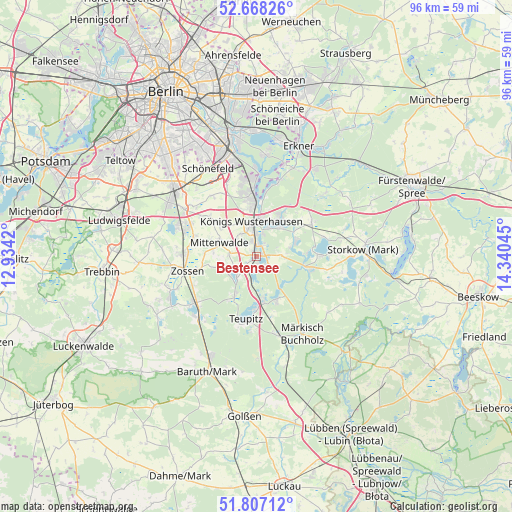
Bestensee GPS coordinates[2]
52° 14' 23.208" North, 13° 38' 14.352" East
| Map corner | latitude | longitude |
|---|---|---|
| Upper-left | 52.66826°, | 12.9342° |
| Center: | 52.23978°, | 13.63732° |
| Lower-right: | 51.80712°, | 14.34045° |
| Map W x H: | 95.7×95.7 km | = 59.5×59.5mi |
| max Lat: | 55.01917° ⇑25.5% North |
| Bestensee: | 52.23978° |
| min Lat: | ⇓74.5% South 47.40724° |
| min Long | Bestensee | max Long |
| 5.92978° | 13.63732° | 14.98853° |
| W 96.6%⇐ | ⇒3.4% E |
Elevation
Elevation of Bestensee is 37 m = 121 ft, and this is 212.1 m = 696 ft below average elevation for this country.
| Max E: |
1256 m = 4121 ft | 84.1% |
| Avg. | 249.1 m = 817 ft | |
| Bestensee | 37 m = 121 ft | |
Min E: |
-5 m = -16 ft | 15.9% |
See also: Germany elevation on elevation.city.
Geographical zone
Bestensee is located in North temperate zone (between Tropic of Cancer and the Arctic Circle). Distance of this North polar circle is 1592.7 km =989.7 mi to North.| Distance of | km | miles | from Bestensee |
|---|---|---|---|
| North Pole | 4198.5 | 2608.8 | to North |
| Arctic Circle | 1592.7 | 989.7 | to North |
| Tropic Cancer | 3202.6 | 1990 | to South |
| Equator | 5808.5 | 3609.2 | to South |


Nearby cities:
15 places around Bestensee: (largest is in red/bold)
• Eichwalde
14.2 km =8.8 mi,  354°
354°
• Groß Köris
8.4 km =5.2 mi,  169°
169°
• Halbe
14.3 km =8.9 mi,  162°
162°
• Hermsdorf
14.1 km =8.8 mi,  130°
130°
• Königs Wusterhausen
6.9 km =4.3 mi,  357°
357°
• Mittenwalde
7 km =4.3 mi,  288°
288°
• Münchehofe
16.9 km =10.5 mi, 127°
• Rangsdorf
15.9 km =9.9 mi, 291°
• Schmöckwitz
15.1 km =9.4 mi,  3°
3°
• Schulzendorf
13.4 km =8.3 mi, 348°
• Schwerin
10 km =6.2 mi,  181°
181°
• Teupitz
12.3 km =7.6 mi,  185°
185°
• Wildau
8.6 km =5.3 mi, 358°
• Zeuthen
12.1 km =7.5 mi, 354°
• Zossen
13.1 km =8.1 mi,  258°
258°
Sources, notices
• [Note1] Compared only with cities in Germany existing in our database
• [Src1] Map data: © OpenStreetMap contributors (CC-BY-SA)
• [Src2] Other city data from geonames.org with taken over terms of usage.
• [Src3] Geographical zone / Annual Mean Temperature by Robert A. Rohde @ Wikipedia
